

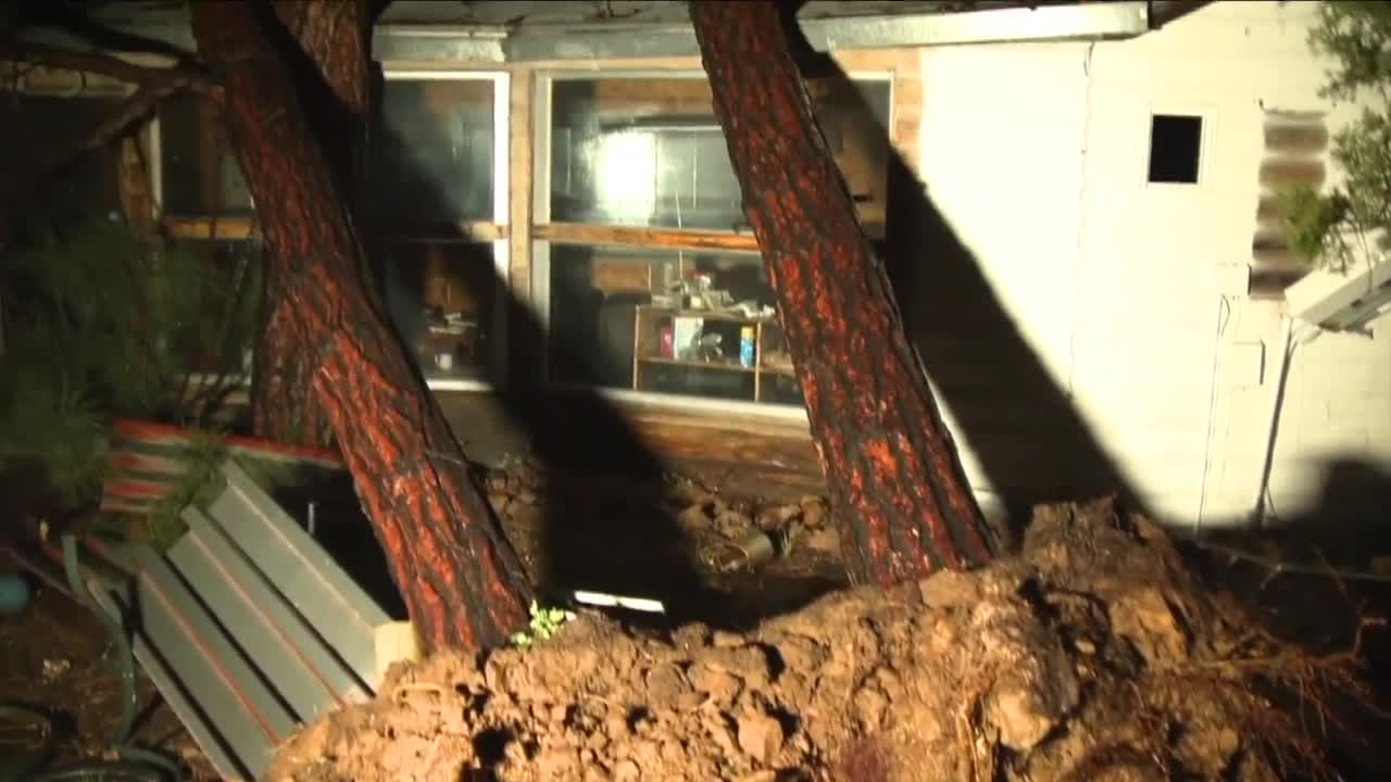


Severe storms have brought large hail, damaging winds, flooding, and even isolated tornadoes to parts of Arizona.
Wednesday and Thursday were ABC15 Weather Action Days as strong storms moved across the Valley and the state.
Communities are now cleaning up after the storms, with closures and damage surveying underway.
HELPFUL LINKS:
Follow the latest updates on the storms below:
9 a.m.
"Heavy rainfall and flooding continue to impact roadways across the Navajo Nation. The Navajo Division of Transportation (NDOT), Navajo Police Department and emergency personnel are responding to washed-out roads, damaged culverts, flooding and hazardous driving conditions," officials say.
5 a.m., Friday
Some Arizona schools will be closed again on Friday, including Moencopi Day School in Tuba City, First Mesa Elementary School in Polacca, and Keams Canyon Elementary School in Keams Canyon.
6:24 p.m.
Kayenta Township has officially declared a State of Emergency effective October 22, 2026, at 3:30 p.m. due to severe rainstorms, flooding, power outages, and impassable roads.
4:50 p.m.
A tornado warning has been issued until 5:15 p.m. for portions of Navajo County which includes Shumway, Pinedale, Linden, Red Top Mountain, Fool Hollow Lake and Schoens Lake.
For more information, you can click here.
2:50 p.m.
Navajo Nation Flash Flooding - Rescues Underway
Kayenta Township · Emergency Flood Response Update - Dennehotso, Arizona October 22, 2026Multiple emergency response agencies are currently on scene in Dennehotso, Arizona, assisting residents affected by severe flash flooding. Responding agencies include the Kayenta Township Fire Department, Navajo Fire, Navajo Nation Department of Emergency Management, Navajo Rangers, Kayenta Navajo Police Department, and Navajo EMS.Emergency personnel are actively conducting evacuation and rescue efforts to reach families and individuals who are stranded in their homes due to rising floodwaters.
The Arizona Department of Public Safety (DPS) is also coordinating the deployment of a helicopter to assist with rescue operations.An Emergency Operations Center (EOC) has been established at the Dennehotso Chapter House to coordinate response efforts and provide assistance to community members.Earlier today, a dam failure contributed to rapidly rising water levels throughout the community, resulting in dangerous flooding conditions. Residents are urged to avoid flooded roadways, follow instructions from emergency responders, and remain alert for updates from local authorities.Our thoughts and prayers are with the families and responders working through this emergency.
1:10 p.m.
⚠️ Tornado Warning ⚠️ in effect until 1:30 PM MST for portions of Apache County. This includes Hawley Lake, Earl Park Lake, Horseshoe Cienega Lake, Williams Creek Hatchery, Cyclone Lake, and Los Burros CG. More info: https://t.co/MSN9TkGJui. #azwx https://t.co/2Il3cdLe6j
— NWS Flagstaff (@NWSFlagstaff) October 22, 2026
12:40 p.m.
⚠️ Tornado Warning ⚠️ in effect until 1:00 PM MST for portions of Navajo and Apache Counties. This includes Porter Mountain Outlook and Mesa Redonda. More info: https://t.co/oIgweoaIxh. #azwx https://t.co/4lMdb0pCqU
— NWS Flagstaff (@NWSFlagstaff) October 22, 2026
10:35 a.m.
SPC has issued a Tornado Watch for much of northern and eastern Arizona until 8 p.m. It does NOT include the Valley.
Areas in the watch: Grand Canyon, Page, Flagstaff, Winslow, Window Rock, Payson, Heber, Show Low, Globe, Safford and Willcox.
Main threats are isolated tornadoes, hail 2 inches or larger, and damaging winds.

10 a.m. - Emergency management officials in Heber-Overgaard provided a 10 a.m. update after a likely tornado caused significant damage to the area last night.
9:40 a.m.
⚠️ Tornado Warning ⚠️ in effect until 10:00 AM MST for portions of Yavapai County. This includes Red Rock State Park, Crescent Moon Ranch, House Mountain Trail Lookout, Baldwin Crossing, Chimney Rock, and Doe Mtn and Bear Mtn Trailheads. More info: https://t.co/l0L7tncaAy. #azwx https://t.co/IdLe9Kt7DJ
— NWS Flagstaff (@NWSFlagstaff) October 22, 2026
⚠️ Severe Thunderstorm Warning ⚠️ in effect until 10:00 AM MST for portions of Coconino County. This includes Starlight Pines, Clints Well, Chavez Mountain, Blue Ridge Reservoir, Sunset Pass, and Long Lake. More info: https://t.co/jgyiF2SLon. #azwx https://t.co/ewAwGEmNWO
— NWS Flagstaff (@NWSFlagstaff) October 22, 2026
9:30 a.m. - The American Red Cross has opened 3 shelters due to severe storms that impacted communities yesterday. While the risk of severe weather continues, the shelters are currently open and available to individuals and families who need assistance. Shelters are currently open at the following locations:
- Desert West Community Center - 6501 W Virginia Ave, Phoenix, AZ 85035
- Capps Middle School - 3375 Buckskin Canyon Rd, Heber, AZ 85928
- Chinle Presbyterian Church - 152 4th Ave, Chinle, AZ 86503
9 a.m. - National Weather Service Flagstaff is sending a crew to the Heber-Overgaard area to survey the damage along with state officials. They are expected to release their findings on the weather event in the area, believed to have been a tornado, early this afternoon.
6:35 a.m. - Phoenix Sky Harbor International Airport is experiencing flight delays due to storms, the Federal Aviation Administration says. Right now, the airport is showing nearly 200 delayed flights.

5:40 a.m. - Schools across Arizona are reporting cancellations on Thursday, with some closures and schedule changes stretching into Friday.
- Moencopi Day School (Tuba City) - "There will be no school for MDS tomorrow, October 22. School is expected to resume Friday, Oct. 23 which will be a half day. Thank you for your understanding."
- First Mesa Elementary School (Polacca) - "FMES parents and guardians there will be no school for tomorrow, Thursday, October 22, 2026 due to inclement weather. The Halloween carnival and bingo that was supposed to be held in the evening is also canceled. We will share a post with the details about rescheduling at a later time."
- Keams Canyon Elementary School (Keams Canyon) - "No School due to Inclement weather on Thursday, 10-22-26"
- HOPI Schools - "All 7 HOPI schools are closed tomorrow, Thursday, October 22nd 2026, due to inclement weather."
- Page Unified School District #8 schools are closed on 10-22
4:30 a.m., Thursday - A Severe Thunderstorm Watch covers most of the state this morning, from the Grand Canyon to Safford and right through the Valley.
Storms could bring large hail, damaging winds and even isolated tornadoes.

8 p.m. - Significant damage is being reported after a likely tornado touched down in Heber-Overgaard Wednesday night, based on ABC15 Desert Doppler radar scans and damage photos and video being submitted by viewers.
ABC15 Chief Meteorologist Amber Sullins says a touchdown likely happened around 8 p.m.
Find the latest information on the situation here.
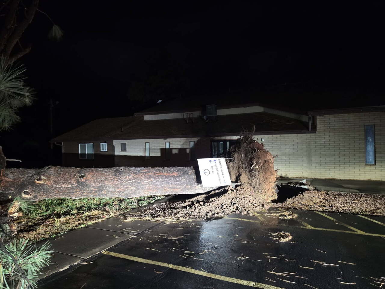
7:15 p.m. - A tornado warning has been issued for Navajo County in north central Arizona until 7:30 MST. Heber-Overgaard, Aripine, Mogollon Airpark and Twin Lake are affected.
6:45 p.m.- Two women captured on camera the moment hail pummeled into the windshield of the vehicle they were in, causing a scare. Thankfully, no one was hurt.
Check out all of the wild weather videos here.
6 p.m.- A tornado warning is in effect until 6:45 p.m. MST for parts of Coconino and Navajo County, including Chevelon Lake.
For more information, you can click here.
4 p.m.- A tornado warning has been issued for South Central Graham County in southeastern Arizona until 4:45 p.m., according to the National Weather Service.
4 p.m.- Thousands are without power as severe storms continue moving across Arizona.
Click here to see a full list of outages.
3:30 p.m.- The National Weather Service has issued a Tornado Watch for parts of Arizona, including Flagstaff, that lasts until 6 p.m. A previous warning in portions of Coconino County expired earlier this morning.
A tornado warning has also been issued for portions of Navajo and Apache Counties until 4 p.m.
⚠️ Tornado Warning ⚠️ in effect until 4:00 PM MST for portions of Navajo and Apache Counties.
— NWS Flagstaff (@NWSFlagstaff) October 21, 2026
This includes Show Low, Vernon, Shumway, White Mountain Lake Estates, Linden, and Wagon Wheel. More info: https://t.co/Iw5aDGuGUg. #azwx pic.twitter.com/jm5MHQgzlu
11 a.m.- Strong storm damaged homes, knocked down trees, and damaged property near University Drive and Gilbert Road in Mesa Tuesday night into Wednesday morning. Jordan Bontke covered the latest on those cleanup efforts:
10 a.m.- See some of the significant damage overnight flash flooding has caused in Clifton, AZ, in the player below.
LOOKING AHEAD:

Valley temperatures will drop into the 70s by Friday as our forecast starts to dry back out. That will put us about 5 degrees below normal for this time of year.

Highs stay near 80 over the weekend, then climb back into the mid-80s early next week. Aside from a few light showers in the high country Saturday, our forecast across most of the state is looking dry.

