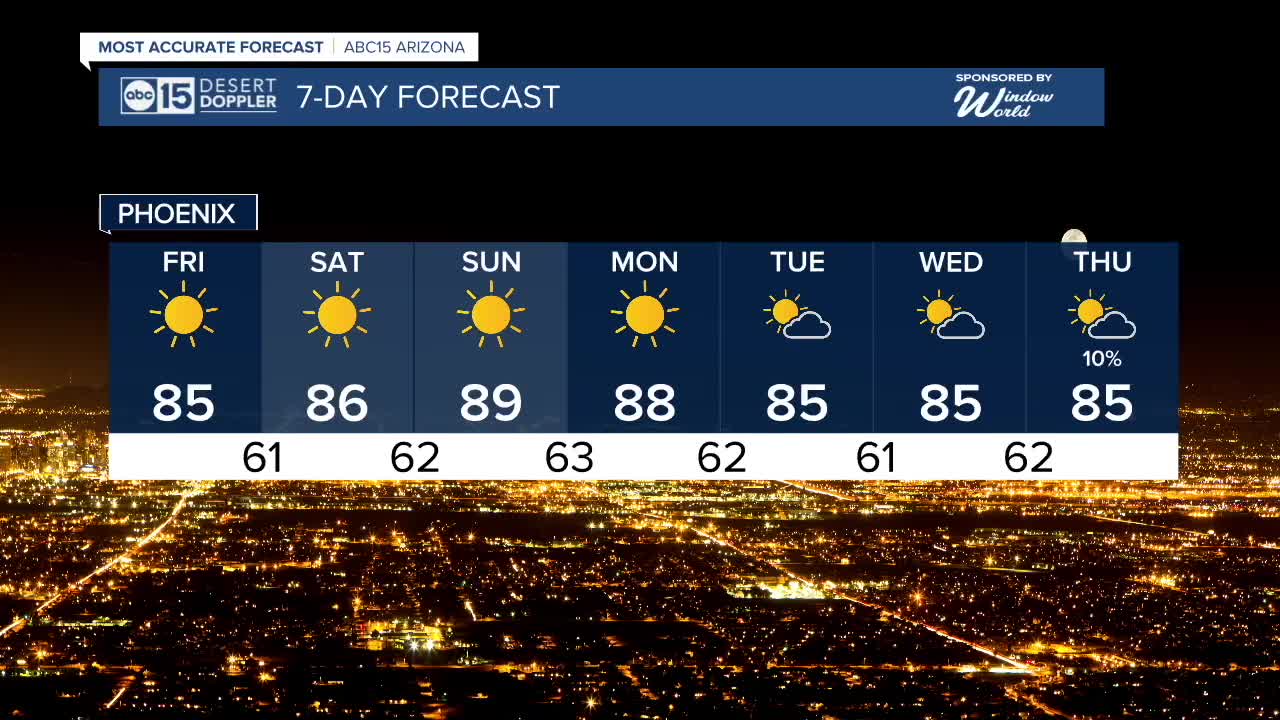


PHOENIX — Our forecast is staying sunny and dry across Arizona as we wrap up the week and head into the weekend.
Valley temperatures will top out in the mid 80s Thursday, Friday and Saturday with overnight lows in the mid 50s to low 60s.
High pressure will intensify over the Southwest over the weekend, bringing temperatures back up into the upper 80s here in the Valley by Sunday.
Phoenix could even break the daily heat record! Sunday's record is 88 degrees set back in 2005.
Temperatures will slowly drop next week and clouds will start to move back in by Tuesday as a storm system approaches from the Pacific.
That storm could even bring some rain chances to Arizona by the the end of the week. So, stay tuned for updates as we get closer!


2025 Sky Harbor Official Rainfall to date: 7.49" (+1.48" from average)
Monsoon 2025 Sky Harbor Official Rainfall: 2.76" (+0.33" from average)
_________________________________________
2024 Sky Harbor Official Rainfall to date: 4.54" (-1.85" from average)
Monsoon 2024 Sky Harbor Official Rainfall: 0.74" (-1.69" from average)
__________________________________________
Daily rainfall reports from all across the Valley can be found here.
__________________________________________
PHOENIX IS GETTING DRIER - LOWER RAINFALL AVERAGES NOW
Average Monsoon Rainfall in Phoenix (1981-2010): 2.71" of rain
NEW Average Monsoon Rainfall in Phoenix (1991-2020): 2.43" of rain
Average Yearly Rainfall in Phoenix (1981-2010): 8:03" of rain
NEW Average Yearly Rainfall in Phoenix (1991-2020): 7.22" of rain
__________________________________________
Share your weather photos and videos with us anytime: share@abc15.com.
______________________________________
