

PHOENIX — We've got a storm system on the way bringing wind, rain and cooler air to Arizona this week!
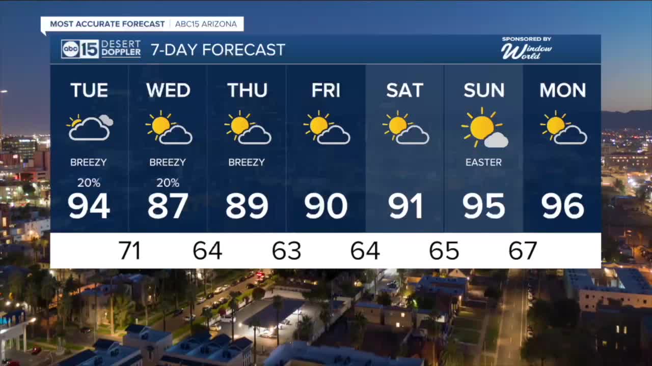
Here in the Valley, expect breezy winds with gusts topping 25 mph at times over the next few days.
We'll also see a chance of rain in the Valley on Tuesday and Wednesday.
The best bet for the most widespread rain will be between 9 p.m. Tuesday evening and 9 a.m. Wednesday morning.
We're not expecting a lot, but some Valley neighborhoods could get a few hundredths of an inch.
Up north, we'll see better chances for measurable rain and maybe even a few snow flurries for areas above 8,000 feet in elevation.
It will get windy up north, too.
Wind Advisories are in effect on Tuesday from 11 a.m. until 8 p.m. from the Grand Canyon to Flagstaff and over to Winslow and Heber. Winds could gust over 45 mph in the these spots.
More Wind Advisories are in effect along the Colorado River in Mohave County from 11 a.m. Tuesday until 2 a.m. Wednesday. Watch out for peak gusts near 50 mph there!
Those winds will usher in some cooler air, dropping temperatures several degrees by Wednesday. That will put the Valley in the mid to upper 80s Wednesday afternoon.
High pressure will return by the end of the week, sending temperatures back into the low to mid 90s through Easter weekend.


2026 Sky Harbor Official Rainfall to date: 0.32" (-2.23" from average)
__________________________________________
Daily rainfall reports from all across the Valley can be found here.
__________________________________________
PHOENIX IS GETTING DRIER - LOWER RAINFALL AVERAGES NOW
Average Monsoon Rainfall in Phoenix (1981-2010): 2.71" of rain
NEW Average Monsoon Rainfall in Phoenix (1991-2020): 2.43" of rain
Average Yearly Rainfall in Phoenix (1981-2010): 8:03" of rain
NEW Average Yearly Rainfall in Phoenix (1991-2020): 7.22" of rain
__________________________________________
Share your weather photos and videos with us anytime: share@abc15.com.
______________________________________
