

PHOENIX — Monday was another record-breaking day in the Valley!
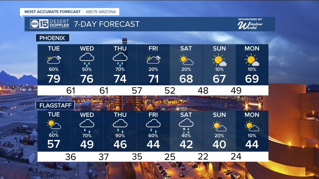
Phoenix hit 83 degrees, breaking the record of 79 set back in 1917.
We could also tie the record of 79 degrees on Tuesday before temperatures drop.
Cooler air and chances for rain will be moving in starting Tuesday evening as a storm heads our way.
With potential impacts to holiday plans and travel across Arizona, Tuesday, Wednesday and Thursday are ABC15 Weather Action Days. Take action and adjust your plans as needed to stay safe in the storm.
The first round of rain will likely arrive after 6 p.m. on Tuesday. Then, rain chances increase even more Wednesday night and into Thursday morning.
Some Valley neighborhoods could pick up a quarter to a half an inch of rain, with higher totals possible across parts of northwestern Arizona.
A Flood Watch is in effect for Mohave County Wednesday morning through Thursday morning, where excessive runoff could lead to flooding in low-lying and flood-prone areas.
Winds will pick up a bit by Wednesday with gusts near 25 mph in the Valley and up to 30 mph in the high country.
Snow levels with this storm system will remain high at 9,000 to 10,000 feet, so Flagstaff will likely only see rain.
There are some lingering chances for precipitation up there into the weekend, and by then we could see some snow flakes come down as colder air settles in.
Here in the Valley, daytime highs will fall into the low 70s by Friday before dropping into the upper 60s over the weekend.
Overnight temperatures will get colder too, with lows falling into the 40s in Phoenix by Sunday morning.
We are also tracking some potential air quality issues this week.
The Arizona Department of Environmental Quality has issued a High Pollution Watch for Thursday due to more holiday burning, which may lead to increased particle pollution.
Air quality will be at its worst during the early morning and late-night hours, so if you have a respiratory condition like asthma, bronchitis, or COPD, try to limit your time outdoors during those periods.


2025 Sky Harbor Official Rainfall to date: 8.28" (+1.29" from average)
Monsoon 2025 Sky Harbor Official Rainfall: 2.76" (+0.33" from average)
__________________________________________
Daily rainfall reports from all across the Valley can be found here.
__________________________________________
PHOENIX IS GETTING DRIER - LOWER RAINFALL AVERAGES NOW
Average Monsoon Rainfall in Phoenix (1981-2010): 2.71" of rain
NEW Average Monsoon Rainfall in Phoenix (1991-2020): 2.43" of rain
Average Yearly Rainfall in Phoenix (1981-2010): 8:03" of rain
NEW Average Yearly Rainfall in Phoenix (1991-2020): 7.22" of rain
__________________________________________
Share your weather photos and videos with us anytime: share@abc15.com.
______________________________________
