

PHOENIX — Southwesterly winds across southern Arizona helped spark scattered storms over Pinal and Pima counties this afternoon. Those storms collapsed, sending outflow boundaries to the northeast into the Valley. Blowing dust is expected across the southeast Valley overnight, which could lead to reduced air quality at times into the morning.
Temperatures are still running warm, but we stayed just shy of record highs Sunday. Increased cloud cover kept readings a few degrees below those records.
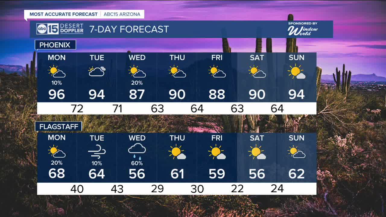
As the ridge of high pressure that brought the recent heat shifts farther east, temperatures will begin a gradual cooldown. At the same time, a bit more moisture could bring showers and thunderstorms to the higher terrain and eastern Arizona on Monday.
In the Valley, the chance for a shower remains low, around 10 percent, mainly late in the day. Most areas will stay dry and warm.
Highs in Phoenix on Monday are expected to reach about 96 degrees. The record for the day is 97 degrees, set in 2004.
By midweek, a weak system approaching from the west will bring breezier conditions and help lower temperatures further. Highs in Phoenix could drop into the 80s by Wednesday, with a slight chance for isolated showers.


2026 Sky Harbor Official Rainfall to date: 0.31" (-2.23" from average)
__________________________________________
Daily rainfall reports from all across the Valley can be found here.
__________________________________________
PHOENIX IS GETTING DRIER - LOWER RAINFALL AVERAGES NOW
Average Monsoon Rainfall in Phoenix (1981-2010): 2.71" of rain
NEW Average Monsoon Rainfall in Phoenix (1991-2020): 2.43" of rain
Average Yearly Rainfall in Phoenix (1981-2010): 8:03" of rain
NEW Average Yearly Rainfall in Phoenix (1991-2020): 7.22" of rain
__________________________________________
Share your weather photos and videos with us anytime: share@abc15.com.
______________________________________
