



PHOENIX — Monsoon storms brought heavy rain and flooding to parts of Arizona again on Tuesday.
Here in the Valley, we'll continue to see chances for showers and thunderstorms through the overnight hours.
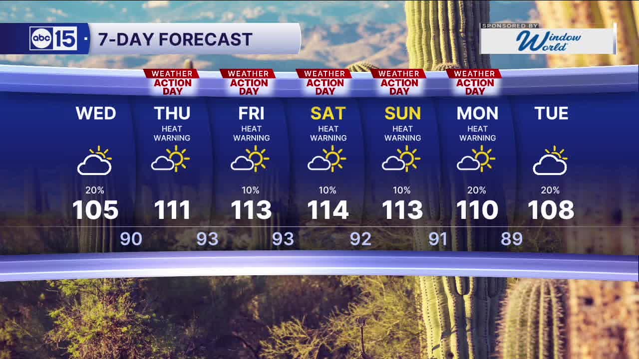
Then, storm chances will die down a bit for the rest of the week as high pressure expands over the Southwest and sends temperatures soaring.
An Extreme Heat Warning has been issued for the Valley Thursday through Monday, as temperatures climb above 110 degrees. Some spots may even approach 115 by Saturday!
We won't get much overnight relief, either. In Phoenix, lows will only fall into the 90s starting Thursday morning.
As temperatures get dangerously hot, Thursday through Monday will all be ABC15 Weather Action Days as a reminder to take action to stay safe in the heat. Limit your time outside in the afternoon and make sure to drink plenty of water throughout the day.
Bring your pets inside to keep them safe from the heat too, and never leave kids or pets in the car.
We are also tracking air quality alerts here in the Valley.
An Ozone High Pollution Watch has been issued for Friday.
If you have asthma, COPD, or any other respiratory issue, limit your time outside in the afternoon hours or you may have difficulty breathing. Exposure to ozone can increase the number and severity of asthma attacks, cause or aggravate bronchitis or other lung disease, and reduce the body's ability to fight infection.
Kids, older adults and anyone trying to exercise outside may experience health impacts from ozone pollution. Symptoms may include itchy eyes, nose and throat, wheezing, coughing, shortness of breath, chest pain, and upper respiratory issues.
We can all help prevent the pollution problem from getting worse. If you have a gas-powered vehicle, try to drive as little as possible this week. Carpooling, working from home, or re-fueling your vehicle after dark helps too.


2026 Sky Harbor Rainfall to-date: 0.76" (-2.72" from average)
2026 Monsoon Rainfall to-date: 0.44" (-0.12" from average)
__________________________________________
Daily rainfall reports from all across the Valley can be found here.
__________________________________________
PHOENIX IS GETTING DRIER - LOWER RAINFALL AVERAGES NOW
Average Monsoon Rainfall in Phoenix (1981-2010): 2.71" of rain
NEW Average Monsoon Rainfall in Phoenix (1991-2020): 2.43" of rain
Average Yearly Rainfall in Phoenix (1981-2010): 8:03" of rain
NEW Average Yearly Rainfall in Phoenix (1991-2020): 7.22" of rain
__________________________________________
Share your weather photos and videos with us anytime: share@abc15.com.
______________________________________
