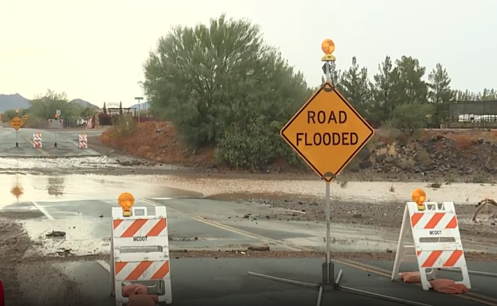


PHOENIX — Monsoon storms are pushing through parts of Arizona and the Valley, with rain chances expected to continue over the next several days.
The National Weather Service issued a Flood Watch for northern, central, and southern Arizona on Thursday as storms have the potential to drop up to three inches of rain per hour. The Flood Watch will be in effect until 5 a.m. on Friday.
If you're seeing weather in your area, send photos and videos to share@abc15.com.
Here are the latest updates on this weather event:
11:50 a.m.
Flash Flood Warning including San Carlos AZ until 3:45 PM MST pic.twitter.com/gY7QY4bOC4
— NWS Phoenix (@NWSPhoenix) July 17, 2026
11:30 a.m.
Flash Flood Warning including Gila County, AZ until 12:15 PM MST pic.twitter.com/MddJ7vPIDt
— NWS Phoenix (@NWSPhoenix) July 17, 2026
6:58 a.m.
We are seeing a rain throughout the Valley this morning.
— Arizona DOT (@ArizonaDOT) July 17, 2026
Please be mindful during your morning commute.
SLOW DOWN. Turn on headlights if using your wipers. Avoid flooded roads & washes. pic.twitter.com/4s1AiKzihN
6 a.m., July 17
Maricopa County Department of Transportation says Desert Hills Road from 15th Avenue to 19th Avenue is closed due to flooding.
10:50 p.m.
Flash Flood Warning including Gila County, AZ, Maricopa County, AZ until 1:45 AM MST pic.twitter.com/XwXX9058Fc
— NWS Phoenix (@NWSPhoenix) July 17, 2026
10:35 p.m.
10:35 PM MST: Flash Flood Warnings are still in effect with a new warning for N Scottsdale and Cave Creek. The west valley is now getting in on the action with additional storms developing over Surprise and Glendale. #azwx pic.twitter.com/kazhx0sVEh
— NWS Phoenix (@NWSPhoenix) July 17, 2026
10:30 p.m.
Flash Flood Warning continues for Roosevelt AZ and Tortilla Flat AZ until 12:45 AM MST pic.twitter.com/yQ1veJCT5c
— NWS Phoenix (@NWSPhoenix) July 17, 2026
10:25 p.m.
Flash Flood Warning including Maricopa County, AZ until 12:45 AM MST pic.twitter.com/yv5kFK8Wvc
— NWS Phoenix (@NWSPhoenix) July 17, 2026
10:05 p.m.
10:00 PM MST Radar Update: Pockets of heavy rainfall have lead to numerous Flash Flood Warnings from far E Maricopa County into S Gila County. Some locations in the warned areas have received over 2” of rainfall. Remember to turn around if encountering flooded roadways! #azwx pic.twitter.com/QvF5a0Lc68
— NWS Phoenix (@NWSPhoenix) July 17, 2026
10:00 p.m.
Flash Flood Warning continues for Maricopa County, AZ until 12:15 AM MST pic.twitter.com/GdUsNSTFOA
— NWS Phoenix (@NWSPhoenix) July 17, 2026
9:55 p.m.
Even though rain is starting to fall across much of the East Valley, power outages right now are not a big problem for APS and SRP. Combined, about 150 customers are currently without power in the Valley.
9:40 p.m.
Flash Flood Warning continues for Apache Junction AZ until 11:15 PM MST pic.twitter.com/XET1eIPBdf
— NWS Phoenix (@NWSPhoenix) July 17, 2026
9:35 p.m.
Flash Flood Warning including Gold Canyon AZ, Queen Valley AZ and Florence Junction AZ until 12:30 AM MST pic.twitter.com/W10rbr9fc1
— NWS Phoenix (@NWSPhoenix) July 17, 2026
9:25 p.m.
Flash Flood Warning including Tonto Basin AZ until 1:30 AM MST pic.twitter.com/0qmoi5CeDT
— NWS Phoenix (@NWSPhoenix) July 17, 2026
9:05 p.m.
Flash Flood Warning including Maricopa County, AZ until 12:00 AM MST pic.twitter.com/NVJM1aUqtT
— NWS Phoenix (@NWSPhoenix) July 17, 2026
9:05 p.m.
9:00 PM MST: An outflow boundary is progressing through the Phoenix Metro which is sparking new thunderstorms, especially in the east valley. Expect showers and storms to blossom over the next 30 minutes with heavy rainfall and flash flooding becoming the main threat. #azwx pic.twitter.com/ScgdqQnlUI
— NWS Phoenix (@NWSPhoenix) July 17, 2026
8:35 p.m.
8:35 PM MST: Numerous Flash Flood Warnings are in effect for Apache Junction, and the Tonto Basin area including all lakes along the Salt River and SR 88. 1-3” of rain has fallen in these areas and flash flooding is likely ongoing. Please avoid travel in these areas. #azwx pic.twitter.com/0poLorCdU7
— NWS Phoenix (@NWSPhoenix) July 17, 2026
8:25 p.m.
Tonight's Valley storms have been stunning!
— Amber Sullins (@AmberSullins) July 17, 2026
This was the view from Chandler Heights and Greenfield of the storm that hit Sun Lakes this evening.
Thanks to ABC15 viewer Lisa Blue for this amazing shot!
Got weather photos/videos to share? Email them to share@abc15.com pic.twitter.com/Nu3KnxPoEQ
7:30 p.m.
Flash Flood Warning including Gila County, AZ until 10:30 PM MST pic.twitter.com/Jhmc5kKfrd
— NWS Phoenix (@NWSPhoenix) July 17, 2026
7:15 p.m.
Flash Flood Warning including Maricopa County, AZ until 10:15 PM MST pic.twitter.com/0x8XdsPjES
— NWS Phoenix (@NWSPhoenix) July 17, 2026
6:50 p.m.
Flash Flood Warning including Apache Junction AZ until 9:45 PM MST pic.twitter.com/HkJ8XLyoXE
— NWS Phoenix (@NWSPhoenix) July 17, 2026
6:50 p.m.
Flash Flood Warning including Apache Junction AZ until 9:45 PM MST pic.twitter.com/HkJ8XLyoXE
— NWS Phoenix (@NWSPhoenix) July 17, 2026
6:35 p.m.
July 16 2026 5:37 PM MST Radar Update: A strong T-Storm has developed over Sun Lakes. Gusty winds and very heavy rainfall are ongoing. Locally, 1/2 in of rain has already fallen as this storm remains nearly stationary. #azwx pic.twitter.com/nObDEKyvo2
— NWS Phoenix (@NWSPhoenix) July 17, 2026
6:30 a.m.
Rainbow in Apache Junction 🌈
— Jordan Bontke (@JBontkeABC15) July 17, 2026
Tracking rain as it rolls into the Valley. @abc15 pic.twitter.com/KMPO4kORDS
5:40 p.m.
July 16 2026 5:37 PM MST Radar Update: A strong T-Storm has developed over Sun Lakes. Gusty winds and very heavy rainfall are ongoing. Locally, 1/2 in of rain has already fallen as this storm remains nearly stationary. #azwx pic.twitter.com/nObDEKyvo2
— NWS Phoenix (@NWSPhoenix) July 17, 2026
1:30 p.m.
Today, the Office of Emergency Management (OEM) enacted the City of Phoenix Sand Deployment Plan. With the possibility of heavy rain over the course of the next several days, the City of Phoenix will deploy publicly available sand bins at 9 different locations across Phoenix.
For a list of locations, specific instructions, and additional information on the Sand Deployment Plan, click here.
The best time to think about sandbags is when the forecast says “chance of storms.”
— The Flood Control District of Maricopa County (@maricopaflood) July 16, 2026
The worst time is when you’re already watching water head toward your garage.
Free sand locations and preparation tips: https://t.co/Z5AJTs6569 pic.twitter.com/hjpVyI3pEF
July 16, 6 a.m.:
A Flood Watch will be in effect for Maricopa, Northwest Pinal, and Southern Gila Counties from 2 PM MST this afternoon through 5 AM MST Friday. Any T-storms that form will be capable of heavy rainfall and will likely be slow moving, increasing the flash flood potential. #azwx pic.twitter.com/ZMNKDDYdcl
— NWS Phoenix (@NWSPhoenix) July 16, 2026
July 15:
Monsoon ramping up the rest of the week:
— Jorge Torres (@JorgeTWeather) July 15, 2026
⛈️ Today: 30% - storms drift into the Valley this evening w/ gusty winds & dust
⛈️ Thu & Fri: 50% - rounds of heavy rain, flooding possible (2-3”/hr rates!) pic.twitter.com/MWWv4Uv6bb
Want more news in your community? Add ABC15 as a preferred source on Google below: