


PHOENIX — Moisture from Raymond is keeping our atmosphere full of tropical humidity, setting the stage for more showers and thunderstorms across Arizona.
- FULL WEATHER SECTION
- INTERACTIVE RADAR
- Email your weather photos and video to share@abc15.com.
Click here to view power outages from APS and SRP across the Valley.
Here are the latest updates we're tracking across the Valley and state during this storm system:
7:29 p.m.
Flash Flood Warning including Apache Junction AZ and Tortilla Flat AZ until 11:15 PM MST pic.twitter.com/OjCKdqW6Ka
— NWS Phoenix (@NWSPhoenix) October 14, 2025
6:47 p.m.
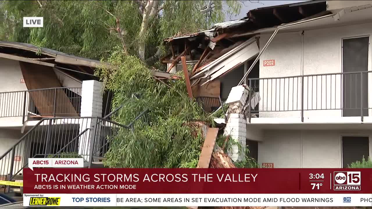
The city of Tempe says they are partnering with the American Red Cross to set up a temporary shelter for those who are displaced.
That shelter will be at the Escalante Multi-Generational Center at 2150 E Orange St.
According to the city, more than 130 people are out of their homes when several apartment buildings were severely damaged by the storm.
6:20 p.m.
Severe Thunderstorm Warning continues for Rio Verde AZ until 6:30 PM MST. This storm will contain two inch sized hail! pic.twitter.com/zc43G6cGdO
— NWS Phoenix (@NWSPhoenix) October 14, 2025
5:50 p.m.
Severe Thunderstorm Warning including Apache Junction AZ, Queen Creek AZ and Fountain Hills AZ until 6:30 PM MST pic.twitter.com/BXoBfskBYK
— NWS Phoenix (@NWSPhoenix) October 14, 2025
4:30 p.m.
TEMPE DAMAGE: multiple areas of Tempe dealing with storm damage from a microburst that hit Tempe, AZ
— Nicole Grigg (@NicoleSGrigg) October 13, 2025
The Broadmor neighborhood dealing with a line of trees up and down the street including one that fell on a home @abc15 pic.twitter.com/LhabzMMsTQ
4:23 p.m.
Air15 also found a tree that had fallen on multiple cars in another part of Tempe.
3:46 p.m.
Air15 flew over damage in the Tempe area where a large building had its roof partially ripped off.
3:14 p.m.
ALL CLEAR - Tempe Campus - The City of Tempe has restored most of the power to the buildings on the Tempe Campus. Continue to use caution around campus. Do not drive through standing water. Please report any life-threatening hazards to the police department.
— Arizona State University Police Department (@ASUPolice) October 13, 2025
3:13 p.m.
We are starting to get a look at what Monday's storms left behind in Tempe and Scottsdale, check out our coverage below.
The National Weather Service has since confirmed that Tempe was hit by a microburst during Monday's storms.
2:31 p.m.
Heavy downpours made their way through north Scottsdale on Monday afternoon. A viewer sent in this video below.
2:08 p.m.
Service Alert Update: Due to severe storms across the Phoenix area, A Line light rail service is currently unavailable between the Downtown Hub station platforms and Gibert Rd/Main St. #azwx #phxtrafficalert #vmservice
— Valley Metro (@valleymetro) October 13, 2025
1:56 p.m.
Advisory - Tempe Campus - The City of Tempe is currently experiencing a wide power outage. Emergency services are working to make repairs as quickly as possible. Do not drive through standing water. Stay indoors. Report any life-threatening hazards to your local pd.
— Arizona State University Police Department (@ASUPolice) October 13, 2025
1:39 p.m.
🚨#TrafficAlert🚨
— ScottsdalePD (@ScottsdalePD) October 13, 2025
The westbound lanes of Bell Rd are BLOCKED near 82nd Street by a tree knocked down by storm activity.
-Please use Perimeter Dr to Princess Dr as an alternate to get around the hazard.@scottsdaleazgov pic.twitter.com/NyYWpaGlXj
1:28 p.m.
🚨 FLASH FLOOD WARNING 🚨
— Jorge Torres (@JorgeTWeather) October 13, 2025
Until 4:15 PM for Maricopa & Pinal counties
Flash flooding is ongoing or starting soon across the East Valley.
⚠️ Life-threatening flooding
💧 Streets + washes flooding
🚗 Dangerous travel conditions
🌩️ Heavy rain building
TURN AROUND, DON’T DROWN pic.twitter.com/fSlGuXIJR2
1:14 p.m.
The intersection of Chandler Blvd/54th St. is blocked due to a large tree blocking the roadway. Avoid area and take and alternate route. #trafficalert pic.twitter.com/c2xh9qNsyQ
— Chandler Police (@ChandlerPolice) October 13, 2025
1:00 p.m.
Severe Thunderstorm Warning for the East Valley until 1:30 pm.
— Jorge Torres (@JorgeTWeather) October 13, 2025
Quarter-size hail and 60 mph gusts possible near Chandler, Guadalupe, Mesa, and Tempe. #azwx pic.twitter.com/HzXdwwpcD0
12:52 p.m.
⚠️ Weather Alert
— City of Mesa, Arizona (@CITYOFMESA) October 13, 2025
A storm is moving through Mesa within the next hour. Expect heavy rain, lightning, and possible localized flooding near retention basins.
Please use caution on the roads, avoid flooded areas, and monitor City updates at https://t.co/1ik8Pw2zfO. pic.twitter.com/cbtDGNtoah
12:50 p.m.
STORMS APPROACHING ⛈️ Storms are approaching the Valley from the south as a flood watch remains in effect through the day. Click here to see live radar! ⬇️ pic.twitter.com/5yPUZmqFV3
— ABC15 Arizona (@abc15) October 13, 2025
Want more news in your community? Add ABC15 as a preferred source on Google below:
![]()

