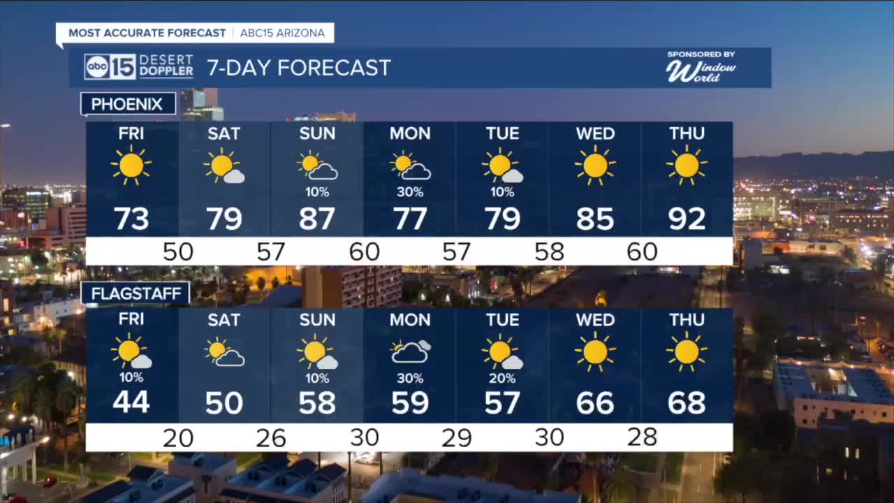


PHOENIX — Winds are picking up across Arizona as a cold front moves in.
Wind gusts in the Valley could top 30 mph this afternoon with much of northern Arizona seeing peak gusts near 45 mph.
Wind Advisories are in effect across Mohave County from until 11 p.m.
Wind Advisories are also in effect along and northeast of the Mogollon Rim until 7 p.m. Watch out for gusts at 40 to 50 mph in places like Flagstaff, Heber and Show Low.
We could also see a few isolated rain and snow showers across northern Arizona as that next storm arrives.
The forecast across central and southern Arizona is looking dry and that will lead to high wildfire danger as winds pick up.
Much of southeastern Arizona is under Red Flag Warnings (also known as Fire Weather Warnings) until 8 p.m.
Winds will die down on Friday as that storm system backtracks to the southwest. It will hover off the coast of Baja California through the weekend, pumping moisture up into parts of Arizona.
By Sunday or Monday, we might even see a few spotty showers in the Valley. We'll keep you posted as we get closer.


2026 Sky Harbor Official Rainfall to date: 0.26" (-1.66" from average)
_________________________________________
2025 Sky Harbor Official Rainfall: 8.31" (+1.09" from average)
Monsoon 2025 Sky Harbor Official Rainfall: 2.76" (+0.33" from average)
__________________________________________
Daily rainfall reports from all across the Valley can be found here.
__________________________________________
PHOENIX IS GETTING DRIER - LOWER RAINFALL AVERAGES NOW
Average Monsoon Rainfall in Phoenix (1981-2010): 2.71" of rain
NEW Average Monsoon Rainfall in Phoenix (1991-2020): 2.43" of rain
Average Yearly Rainfall in Phoenix (1981-2010): 8:03" of rain
NEW Average Yearly Rainfall in Phoenix (1991-2020): 7.22" of rain
__________________________________________
Share your weather photos and videos with us anytime: share@abc15.com.
______________________________________
