

PHOENIX — After a quiet and warm weekend, we’re tracking some notable changes heading into the week.
First, a weak disturbance will move across Northern Arizona overnight into early Monday, bringing isolated rain and snow showers above 7,000 feet. Impacts with this system will be minimal.
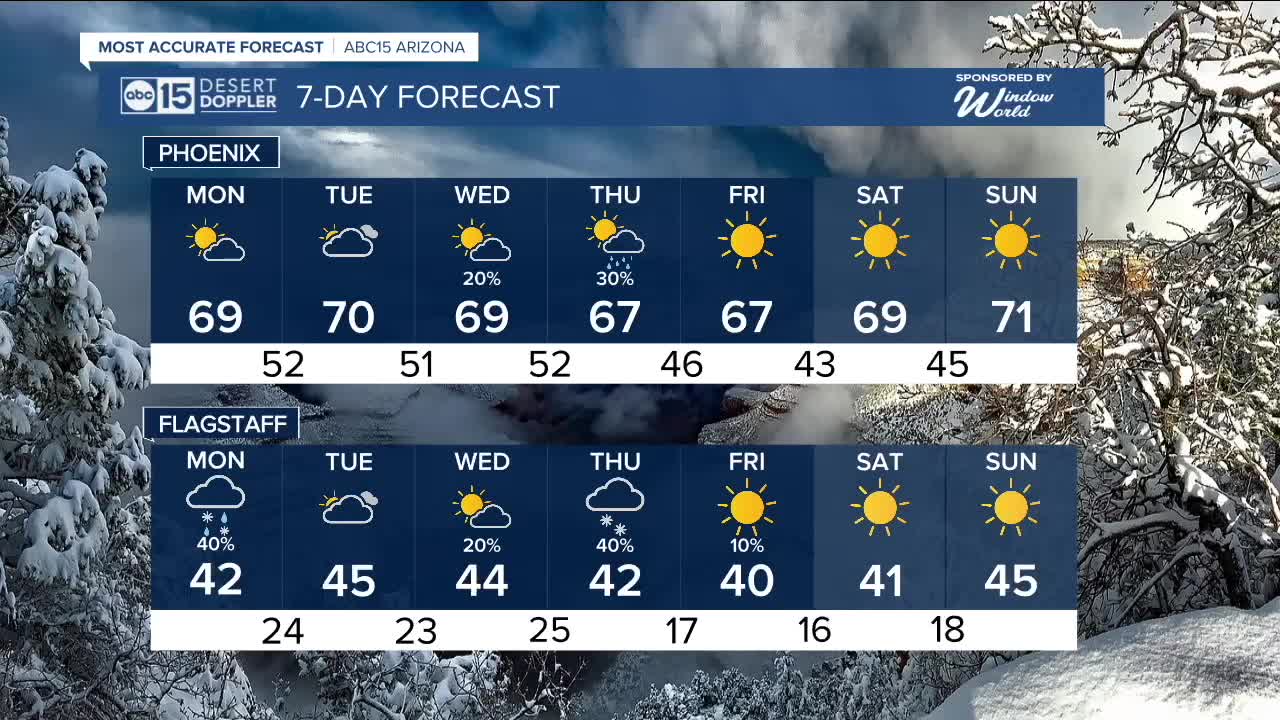
The Valley stays quiet and dry to start the week, with partly cloudy skies Monday and increasing clouds on Tuesday. Morning lows will be in the lower to mid-50s, with afternoon highs in the upper 60s to near 70.
By midweek, attention turns to two low-pressure systems that models are still struggling to pin down — making this a potential rain/snow-or-bust setup.
System one: A cut-off low moves to our south, bringing a rain chance primarily for southern and southeast Arizona. If this lifts further north, that would increase Valley rain chances.
System two: The jet stream digs south to pick up that cut off low, the further south the jet stream dips, the better the rain and snow chance for State 48. We are also watching how much cold air intrudes with this; if it runs colder, we could see accumulating snow for the Mogollon Rim and high country.
Temperatures will trend cooler as well. Valley highs could drop into the low to mid-60s late next week, with morning lows in the low 40s. The average high for this time of year in Phoenix is 66 degrees.
Looking ahead, the longer-term January outlook favors warmer-than-normal conditions.
Phoenix just wrapped up its second-warmest year on record. The average temperature for 2025 came in at 78.1 degrees — just half a degree below the 2024 record of 78.6 degrees.


2026 Sky Harbor Official Rainfall to date: 0.03" (-0.09" from average)
__________________________________________
2025 Sky Harbor Official Rainfall: 8.31" (+1.09" from average)
Monsoon 2025 Sky Harbor Official Rainfall: 2.76" (+0.33" from average)
__________________________________________
Daily rainfall reports from all across the Valley can be found here.
__________________________________________
PHOENIX IS GETTING DRIER - LOWER RAINFALL AVERAGES NOW
Average Monsoon Rainfall in Phoenix (1981-2010): 2.71" of rain
NEW Average Monsoon Rainfall in Phoenix (1991-2020): 2.43" of rain
Average Yearly Rainfall in Phoenix (1981-2010): 8:03" of rain
NEW Average Yearly Rainfall in Phoenix (1991-2020): 7.22" of rain
__________________________________________
Share your weather photos and videos with us anytime: share@abc15.com.
______________________________________
