

PHOENIX — It's a warm start to the week in the Valley!
With high pressure in control, temperatures are running several degrees above normal for this time of year.
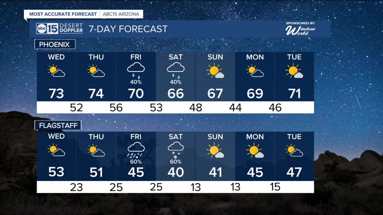
Valley temperatures will top out in the 70s through Thursday, with overnight lows in the 40s.
Maricopa County is also under a "No Burn Day" on Tuesday due to elevated particle pollution in the area. This means wood burning is prohibited. Do not burn wood in your fireplaces, stoves or outdoor firepits.
If you have any respiratory issues, like asthma, bronchitis or COPD, limit your time outside or you have may difficulty breathing.
Clouds will start moving in on Wednesday and Thursday ahead of the next storm system we are tracking.
That storm will bring rain and snow back to Arizona on Friday and Saturday, which could impact outdoor activities and travel across the state.
Friday and Saturday will be ABC15 Weather Action Days as a reminder to take action and adjust your plans to stay safe in the storm.
We could see accumulating snow across parts of the high country over 6,000 feet in elevation by Saturday morning.
It's still too soon to know how much rain and snow we could get, but we'll keep you posted as we get closer.
Temperatures will drop, too.
Valley highs will fall into the 60s on Saturday and Sunday, which is finally near normal for this time of year!


2026 Sky Harbor Official Rainfall to date: 0.18" (-0.42" from average)
_________________________________________
2025 Sky Harbor Official Rainfall: 8.31" (+1.09" from average)
Monsoon 2025 Sky Harbor Official Rainfall: 2.76" (+0.33" from average)
_________________________________________
Daily rainfall reports from all across the Valley can be found here.
__________________________________________
PHOENIX IS GETTING DRIER - LOWER RAINFALL AVERAGES NOW
Average Monsoon Rainfall in Phoenix (1981-2010): 2.71" of rain
NEW Average Monsoon Rainfall in Phoenix (1991-2020): 2.43" of rain
Average Yearly Rainfall in Phoenix (1981-2010): 8:03" of rain
NEW Average Yearly Rainfall in Phoenix (1991-2020): 7.22" of rain
__________________________________________
Share your weather photos and videos with us anytime: share@abc15.com.
______________________________________
