

PHOENIX — It was a hazy Sunday across the Valley as overnight storms in southern Arizona pushed an outflow boundary north, kicking up dust.
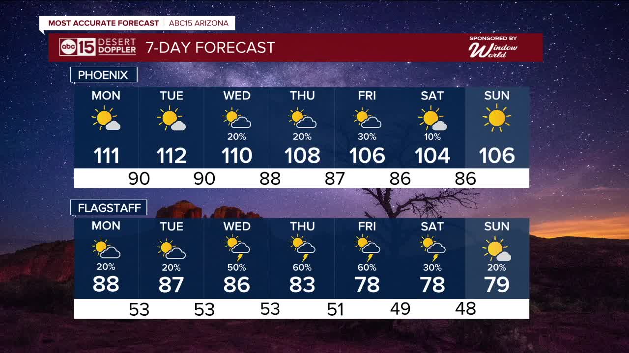
The dusty skies kept temperatures slightly lower than expected, with a high of 108 degrees. But prepare for more extreme heat — temperatures at or above 110 are expected through the first half of the week.
An Extreme Heat Warning remains in effect for central and southwestern Arizona through 8 p.m. Tuesday. For the Grand Canyon below 4,000 feet, the warning remains in effect through Thursday night. A new Extreme Heat Warning is also in effect for northwestern Arizona on Monday and Tuesday.
A Heat Advisory will be in place for the Northwest Plateau on Monday and Tuesday.
We will remain in ABC15 Weather Action Days through Tuesday. Be sure to take precautions to protect yourself, your family, and your pets. Avoid contact with hot surfaces like car doors, steering wheels, and playground equipment, which can cause serious burns within seconds.
By midweek, monsoon moisture is expected to return to Arizona as high pressure builds over the Four Corners region. Rain chances will increase later in the week.
The best chance for storms in the Valley is Thursday and Friday. Stay tuned for the latest updates.


_________________________________________
2025 Sky Harbor Official Rainfall to date: 1.63" (-2.53" from average)
Monsoon 2025 Sky Harbor Official Rainfall: 0.16" (-1.05" from average)
__________________________________________
Daily rainfall reports from all across the Valley can be found here.
__________________________________________
PHOENIX IS GETTING DRIER - LOWER RAINFALL AVERAGES NOW
Average Monsoon Rainfall in Phoenix (1981-2010): 2.71" of rain
NEW Average Monsoon Rainfall in Phoenix (1991-2020): 2.43" of rain
Average Yearly Rainfall in Phoenix (1981-2010): 8:03" of rain
NEW Average Yearly Rainfall in Phoenix (1991-2020): 7.22" of rain
__________________________________________
Share your weather photos and videos with us anytime: share@abc15.com.
______________________________________
