

PHOENIX — Extreme heat continues across Arizona!
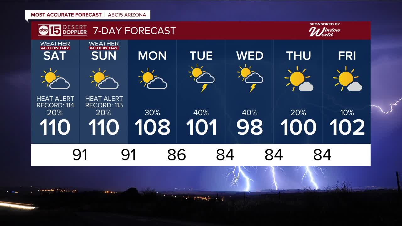
Our Extreme Heat Warning in the Valley has now been extended through Sunday evening, so we are in ABC15 Weather Action mode as a reminder to take action to stay safe in these potentially dangerous temperatures.
Make sure to stay hydrated with water and electrolytes, limit outdoor activities between 10 a.m. and 6 p.m. and bring your pets inside.
Also, keep in mind, many popular hiking trails will be closed during this Extreme Heat Warning.
Our Valley heat risk will be major to extreme on the scale, which means all of us will be vulnerable to heat-related illnesses like heat exhaustion or heat stroke if we don't have adequate cooling or hydration. So stay safe and seek air-conditioned spaces as much as possible.
Phoenix will likely top out around 110 degrees over the weekend with overnight lows in the 90s.
Air quality has been getting worse, too.
Ozone High Pollution Advisories are now in effect through Sunday
Ozone pollution can trigger chest pain, coughing, throat irritation, congestion, and breathing difficulties, especially in children, older adults, and those with asthma, bronchitis, or COPD. Try to limit outdoor activities during the afternoon hours when ozone pollution is at its worst.
We can all help reduce ozone pollution by carpooling, using public transportation, or working from home. Also, avoid idling in long drive-thru lines and wait until after dark to refuel your gas-powered vehicles.
With monsoon moisture in place, we could also see showers and thunderstorms each day across parts of Arizona.
Here in the Valley, there is a slight chance storms could move in off of the higher terrain to our northeast in the late afternoon and evening on Saturday and Sunday.
Watch out for gusty winds, blowing dust, cloud-to-ground lightning and pockets of heavy rain that could lead to localized flooding.
Monsoon storm chances will increase next week as temperatures drop across Arizona.
Expect Valley highs in the upper 90s to low 100s next Tuesday, Wednesday and Thursday with a chance of scattered monsoon storms on those days.


2025 Sky Harbor Official Rainfall to date: 1.67" (-2.84" from average)
Monsoon 2025 Sky Harbor Official Rainfall: 0.20" (-1.36" from average)
__________________________________________
Daily rainfall reports from all across the Valley can be found here.
__________________________________________
PHOENIX IS GETTING DRIER - LOWER RAINFALL AVERAGES NOW
Average Monsoon Rainfall in Phoenix (1981-2010): 2.71" of rain
NEW Average Monsoon Rainfall in Phoenix (1991-2020): 2.43" of rain
Average Yearly Rainfall in Phoenix (1981-2010): 8:03" of rain
NEW Average Yearly Rainfall in Phoenix (1991-2020): 7.22" of rain
__________________________________________
Share your weather photos and videos with us anytime: share@abc15.com.
______________________________________
