



PHOENIX — Our latest fall storm system brought rounds of rain over the past couple of days. A few showers and isolated storms linger in northeast Arizona this morning before ending by sunset.
The rest of the state is drying back out as some cooler fall air settles in.
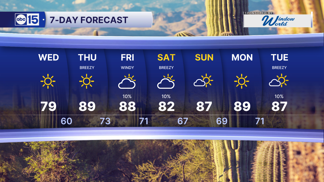
Valley highs will top out in the upper 70s to near 80 today, putting us nearly 10 degrees below normal for this time of year.
Overnight lows will get chilly, too.
A Freeze Warning is in effect until 8 a.m. this morning for Flagstaff, Williams, and the Grand Canyon.
Higher elevations from the Kaibab Plateau to the Chuska Mountains also picked up a light dusting of snow. Valley temperatures will drop to near 60 by Thursday morning.
We warm back up on Thursday and Friday with highs in the upper 80s across the Valley.
Winds will crank up later this week as our next storm system sits to the southwest and strong high pressure pushes in from the east.
Wind Advisories will be in effect for much of southeastern Arizona from 11 p.m. Thursday until 11 a.m. Saturday. Expect east to southeast winds of 30 to 35 mph, with gusts of 50 to 60 mph.
Wind Advisories are also in effect Friday for Pinal, southern Maricopa, and Yuma counties, with gusts over 40 mph and some gusts up to 50 mph.
Wind like that is strong enough to kick up blowing dust and drop visibility below a mile at times, especially in Pinal County. Crosswinds will make driving tough, especially for larger vehicles. Secure anything loose in your yard. Some tree damage and power outages are possible too.
Here in the Valley, gusts of 30 to 40 mph are possible Friday morning. It will still be quite breezy on Saturday too, with gusts of 25 to 35 mph.
Gusts of 35 to 45 mph are expected in the high country Thursday evening into Friday, strongest along and just south of the Mogollon Rim.
We’re also tracking some moisture flowing in that could bring a slight chance of spotty showers across central and southern Arizona late Friday and Saturday. Most spots will only see a trace to a few hundredths of an inch.
Some moisture from Hurricane Simon could also get pulled close to Arizona this weekend, so we’ll be watching that.
Highs dip back to the low 80s on Saturday before warming into the upper 80s early next week.
Another storm system could bring more rain chances and cooler temperatures by the middle of next week.


2026 Sky Harbor Official Rainfall to date: 3.19" (-2.40" from average)
Monsoon 2026 Sky Harbor Official Rainfall: 2.46" (+0.03" from average)
__________________________________________
Daily rainfall reports from all across the Valley can be found here.
__________________________________________
PHOENIX IS GETTING DRIER - LOWER RAINFALL AVERAGES NOW
Average Monsoon Rainfall in Phoenix (1981-2010): 2.71" of rain
NEW Average Monsoon Rainfall in Phoenix (1991-2020): 2.43" of rain
Average Yearly Rainfall in Phoenix (1981-2010): 8:03" of rain
NEW Average Yearly Rainfall in Phoenix (1991-2020): 7.22" of rain
__________________________________________
Share your weather photos and videos with us anytime: share@abc15.com.
______________________________________
