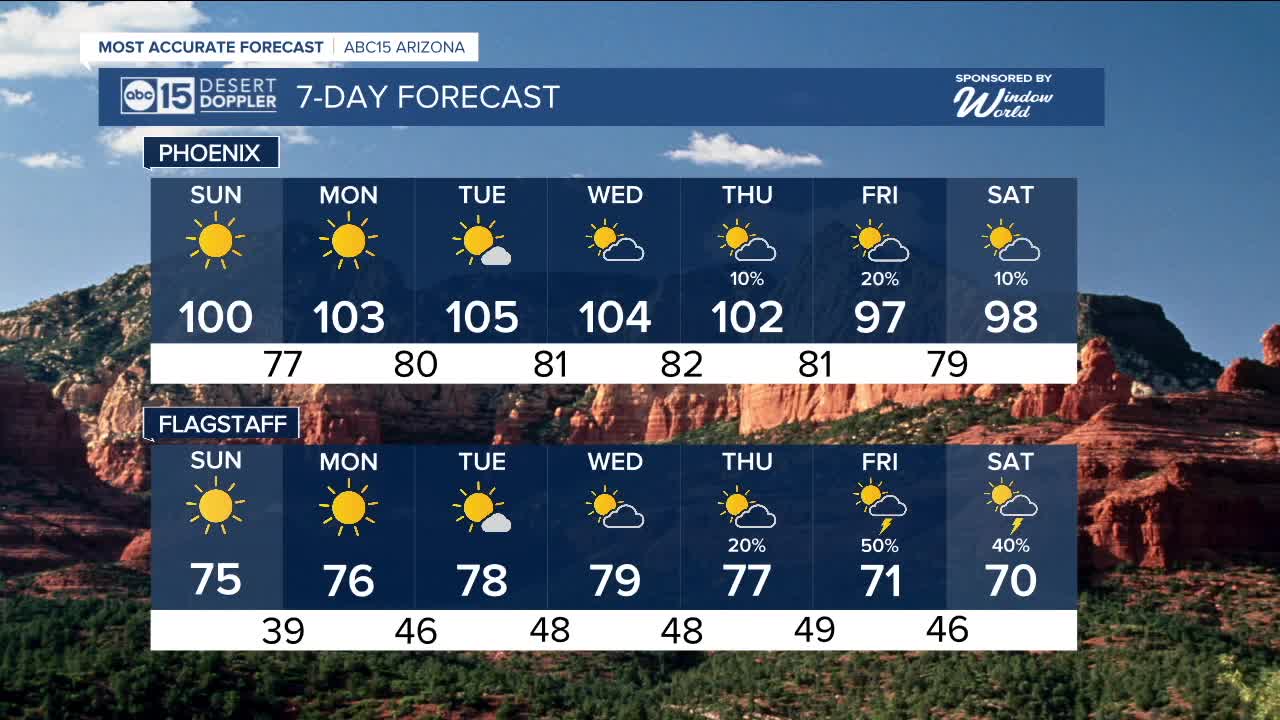


PHOENIX — A storm system moving to our north is ushering in much cooler weather and giving u a hint a fall, but it will be short-lived.
Get ready for a cool start to our Sunday morning. Although the city will only drop to the mid-70s, so communities across the Valley will wake up to temperatures in the lower 70s and even upper 60s.
While it may start out cool, temperatures are set to warm back up closer to normal in the afternoon, but overall it should still be a nice day with a high around 100 degrees.
Much of the state will stay dry aside from a few storms to the southeast. Storm chances are set to ramp up late week as high pressure builds back in.
As high pressure returns next week, we'll climb back above normal to start the new week with highs up to 105 by Tuesday.
Monsoon moisture will start to flow back in mid-week and could be enhanced by tropical moisture that moves up the Baja
While there is still a high degree of uncertainty in how much moisture moves in, it could really increase storm chances across Arizona toward the end of next week as another storm system moves in from the northwest at the same time.
We're closely monitoring this complex setup and how it could impact the Valley. We will have updates for you as we get closer.


_________________________________________
2025 Sky Harbor Official Rainfall to date: 2.15" (-2.90" from average)
Monsoon 2025 Sky Harbor Official Rainfall: 0.68" (-1.43" from average)
__________________________________________
Daily rainfall reports from all across the Valley can be found here.
__________________________________________
PHOENIX IS GETTING DRIER - LOWER RAINFALL AVERAGES NOW
Average Monsoon Rainfall in Phoenix (1981-2010): 2.71" of rain
NEW Average Monsoon Rainfall in Phoenix (1991-2020): 2.43" of rain
Average Yearly Rainfall in Phoenix (1981-2010): 8:03" of rain
NEW Average Yearly Rainfall in Phoenix (1991-2020): 7.22" of rain
__________________________________________
Share your weather photos and videos with us anytime: share@abc15.com.
______________________________________
