

PHOENIX — Phoenix set a new record high Sunday, with afternoon temperatures climbing to 85 degrees. That breaks the previous record of 83 degrees set in 2003.
High pressure remains in control, keeping temperatures more than 10-15 degrees above normal as we head into the first full week of February.
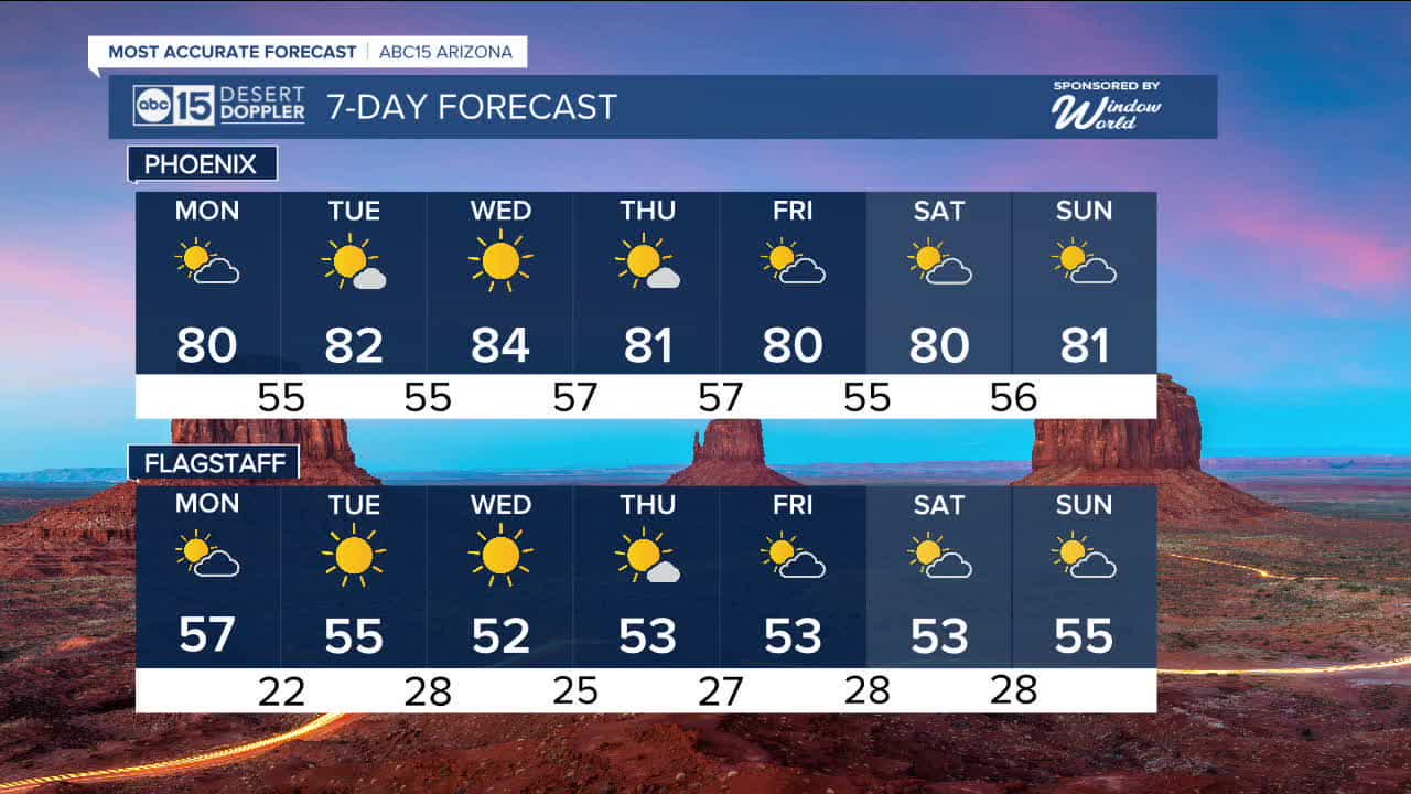
Phoenix could come close to another record on Monday and Thursday. The record high Monday is 82 degrees, set just last year, and we’re forecasting a high near 80.
The slight drop in highs on Monday is due to increasing clouds across the Valley as we watch a brief weakening in the ridge of high pressure.
However, that ridge strengthens again by midweek, keeping afternoon highs in the 80s through the week and into next weekend.
Morning lows will stay mild and comfortable, generally in the mid-50s.
Breezy conditions are possible at times, with Thursday shaping up to be the windiest day. Wind gusts could reach 20 to 25 mph.
While the pattern stays quiet and warm for now, we’re watching a possible shift between February 9 and 15. That change could bring back rain chances across the state. Stay tuned as we get closer to midmonth.


2026 Sky Harbor Official Rainfall to date: 0.18" (-0.72" from average)
_________________________________________
2025 Sky Harbor Official Rainfall: 8.31" (+1.09" from average)
Monsoon 2025 Sky Harbor Official Rainfall: 2.76" (+0.33" from average)
__________________________________________
Daily rainfall reports from all across the Valley can be found here.
__________________________________________
PHOENIX IS GETTING DRIER - LOWER RAINFALL AVERAGES NOW
Average Monsoon Rainfall in Phoenix (1981-2010): 2.71" of rain
NEW Average Monsoon Rainfall in Phoenix (1991-2020): 2.43" of rain
Average Yearly Rainfall in Phoenix (1981-2010): 8:03" of rain
NEW Average Yearly Rainfall in Phoenix (1991-2020): 7.22" of rain
__________________________________________
Share your weather photos and videos with us anytime: share@abc15.com.
______________________________________
