

PHOENIX — Temperatures have been soaring across Arizona!
The Valley is starting the week with near-record warmth again. Phoenix ended up just one degree shy of the record on Monday with a high of 85 degrees. That's 15 degrees above normal for this time of year.
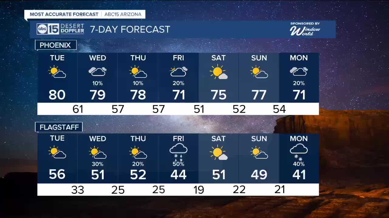
Temperatures will drop a few degrees on Tuesday as clouds move in late in the day. Look for highs in the upper 70s to low 80s across the Phoenix metro area.
A quick-moving storm system to our south could bring some light spotty showers to parts of our state late Tuesday and Wednesday, but not much measurable rain is expected.
Here in the Valley, there's just a 10 percent chance of a few sprinkles.
A stronger storm system is expected to move in late Thursday and Friday, bringing rain chances to the Valley and a dusting of snow to parts of the high country.
Early estimates show a snow level around 7,000 feet in elevation. We'll keep you posted as we get closer.
That storm will finally bring some cooler air our way, too!
Valley highs will fall into the low 70s by the end of the week, which is right near normal for this time of year.


2026 Sky Harbor Official Rainfall to date: 0.18" (-0.92" from average)
_________________________________________
2025 Sky Harbor Official Rainfall: 8.31" (+1.09" from average)
Monsoon 2025 Sky Harbor Official Rainfall: 2.76" (+0.33" from average)
_________________________________________
Daily rainfall reports from all across the Valley can be found here.
__________________________________________
PHOENIX IS GETTING DRIER - LOWER RAINFALL AVERAGES NOW
Average Monsoon Rainfall in Phoenix (1981-2010): 2.71" of rain
NEW Average Monsoon Rainfall in Phoenix (1991-2020): 2.43" of rain
Average Yearly Rainfall in Phoenix (1981-2010): 8:03" of rain
NEW Average Yearly Rainfall in Phoenix (1991-2020): 7.22" of rain
__________________________________________
Share your weather photos and videos with us anytime: share@abc15.com.
______________________________________
