

PHOENIX — Isolated showers and thunderstorms are still possible in parts of our state, but drier air is on the way.
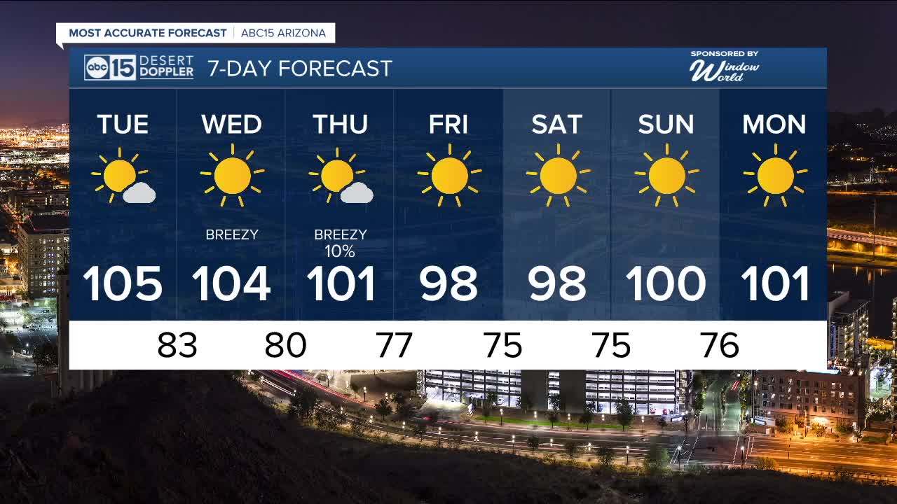
That drier air will bring humidity down in the Valley starting Tuesday as temperatures top out around 105 degrees once again.
Cooler air is on the way, though!
We are tracking a storm system that will pass to our north during the middle of the week, picking up winds across Arizona and dropping temperatures.
Here in the Valley, peak gusts could hit 30 mph at times on Wednesday and Thursday, with gusts up to 40 mph possible across the high country.
We may also see a few isolated showers as this storm system passes by, but chances are low (at just 10 percent) in the Valley on Thursday.
As the cooler air moves in with this storm system, temperatures will drop nearly 10 degrees in many Arizona spots by Friday.
Valley highs will drop into the upper 90s with early morning lows in the low to mid 70s.
We'll gradually warm back up over the weekend and approach 100 degrees in Phoenix again on Sunday.


2025 Sky Harbor Official Rainfall to date: 2.15" (-2.82" from average)
Monsoon 2025 Sky Harbor Official Rainfall: 0.68" (-1.35" from average)
__________________________________________
Daily rainfall reports from all across the Valley can be found here.
__________________________________________
PHOENIX IS GETTING DRIER - LOWER RAINFALL AVERAGES NOW
Average Monsoon Rainfall in Phoenix (1981-2010): 2.71" of rain
NEW Average Monsoon Rainfall in Phoenix (1991-2020): 2.43" of rain
Average Yearly Rainfall in Phoenix (1981-2010): 8:03" of rain
NEW Average Yearly Rainfall in Phoenix (1991-2020): 7.22" of rain
__________________________________________
Share your weather photos and videos with us anytime: share@abc15.com.
______________________________________
