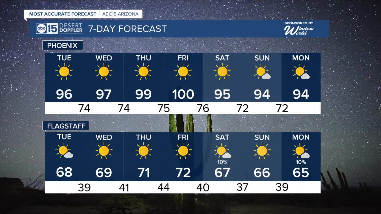


PHOENIX — High pressure is building in and bringing a big warm-up to the Valley this week.
Daytime highs will top out in the mid 90s Tuesday and Wednesday before climbing into the upper 90s on Thursday. By Friday, Phoenix may even hit 100 degrees.
Overnight lows will drop into the low to mid 70s across the Valley each night.
Our forecast will stay sunny and dry all week, but we are tracking a couple of weak storm systems over the weekend and early next week that may bring a few isolated showers to the high country.
Slight chance of spotty showers and isolated thunderstorms will be in the forecasts across northern Arizona on Saturday and next Monday.
As the 2025 monsoon season comes to an end on September 30th, Phoenix will wrap up with 2.76 inches of rain, putting us more than a quarter of an inch above the average of 2.43 inches. The last time we had an above-normal monsoon was in 2021.


_________________________________________
2025 Sky Harbor Official Rainfall to date: 4.23" (-1.10" from average)
Monsoon 2025 Sky Harbor Official Rainfall: 2.76" (+0.33" from average)
__________________________________________
Daily rainfall reports from all across the Valley can be found here.
__________________________________________
PHOENIX IS GETTING DRIER - LOWER RAINFALL AVERAGES NOW
Average Monsoon Rainfall in Phoenix (1981-2010): 2.71" of rain
NEW Average Monsoon Rainfall in Phoenix (1991-2020): 2.43" of rain
Average Yearly Rainfall in Phoenix (1981-2010): 8:03" of rain
NEW Average Yearly Rainfall in Phoenix (1991-2020): 7.22" of rain
__________________________________________
Share your weather photos and videos with us anytime: share@abc15.com.
______________________________________
