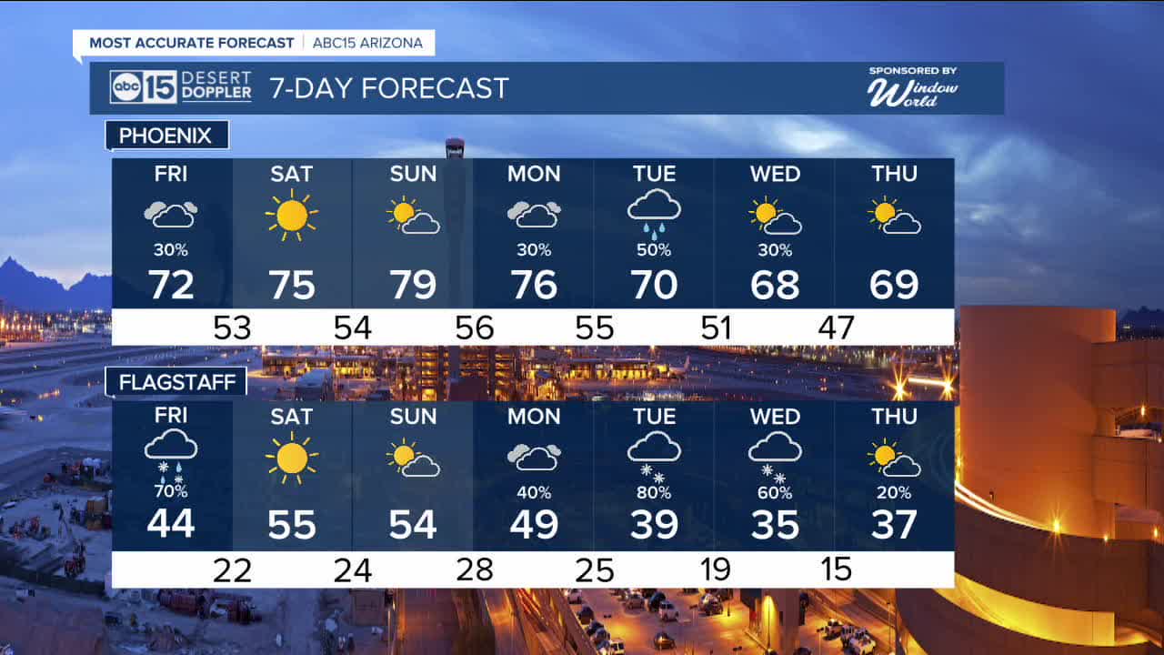


PHOENIX — Clouds are moving in ahead of our next storm.
We could see a few spotty showers and thunderstorms across western and northern Arizona today, but rain chances will hold off until Friday here in the Valley.
Our best bet for measurable rain in Phoenix will be Friday afternoon and early evening. There's a slight chance of a few thunderstorms in the mix, too.
Showers will be hit or miss, but the spots that do see rain could get up to a tenth of an inch.
Up north, the snow level will be around 7,000 feet in elevation with up to an inch of snow possible in Flagstaff.
This storm will clear out early Saturday morning and high pressure will build in over the weekend.
Expect sunny skies and Valley highs in the mid 70s on Saturday for Valentine's Day. Then, we'll climb back into the upper 70s on Sunday.
Another storm system will move in from the west early next week. That one could bring more measurable rain to the Valley and snow to areas above 6,000 feet in elevation.
Rain chances are now in the forecast on Monday, Tuesday and Wednesday as temperatures gradually drop into the upper 60s here in Phoenix by the middle of next week.
We'll have updates on how much rain and snow we could see across Arizona in the next couple of days.


2026 Sky Harbor Official Rainfall to date: 0.18" (-1.00" from average)
_________________________________________
2025 Sky Harbor Official Rainfall: 8.31" (+1.09" from average)
Monsoon 2025 Sky Harbor Official Rainfall: 2.76" (+0.33" from average)
__________________________________________
Daily rainfall reports from all across the Valley can be found here.
__________________________________________
PHOENIX IS GETTING DRIER - LOWER RAINFALL AVERAGES NOW
Average Monsoon Rainfall in Phoenix (1981-2010): 2.71" of rain
NEW Average Monsoon Rainfall in Phoenix (1991-2020): 2.43" of rain
Average Yearly Rainfall in Phoenix (1981-2010): 8:03" of rain
NEW Average Yearly Rainfall in Phoenix (1991-2020): 7.22" of rain
__________________________________________
Share your weather photos and videos with us anytime: share@abc15.com.
______________________________________
