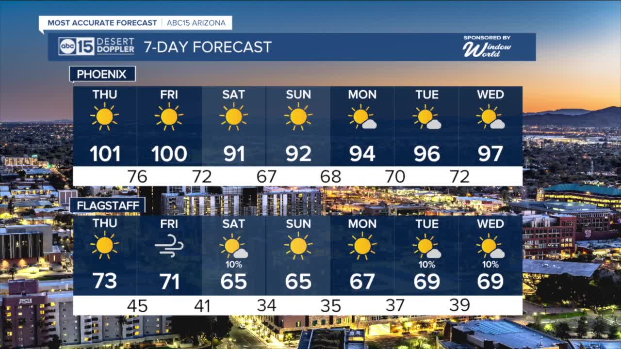


PHOENIX — High pressure is building in and bringing a big warm-up to Arizona this week!
Valley temperatures are expected to top out in the low 100s on Thursday and Friday.
Overnight lows will drop into the low to mid 70s across the Valley each night.
Our Valley forecast will stay sunny and dry, but we are tracking a couple of weak storm systems over the weekend and next week that may bring a few isolated showers to parts of the high country.
Spotty showers and isolated thunderstorms will be possible across northern Arizona on Saturday and again next Tuesday and Wednesday.
The first storm system, passing to our north on Friday and Saturday, will also pick up winds across our state.
Gusts could hit 25 mph in the Valley and 35 mph across the high country by the end of the week.
Those winds will usher in some cooler air, dropping temperatures 8 to 12 degrees across Arizona.
Here in the Valley, that will put daytime highs back in the low 90s over the weekend.


_________________________________________
2025 Sky Harbor Official Rainfall to date: 4.23" (-1.14" from average)
Monsoon 2025 Sky Harbor Official Rainfall: 2.76" (+0.33" from average)
__________________________________________
Daily rainfall reports from all across the Valley can be found here.
__________________________________________
PHOENIX IS GETTING DRIER - LOWER RAINFALL AVERAGES NOW
Average Monsoon Rainfall in Phoenix (1981-2010): 2.71" of rain
NEW Average Monsoon Rainfall in Phoenix (1991-2020): 2.43" of rain
Average Yearly Rainfall in Phoenix (1981-2010): 8:03" of rain
NEW Average Yearly Rainfall in Phoenix (1991-2020): 7.22" of rain
__________________________________________
Share your weather photos and videos with us anytime: share@abc15.com.
______________________________________
