

PHOENIX — High pressure is building in over the Desert Southwest, bringing a major warm-up to Arizona!
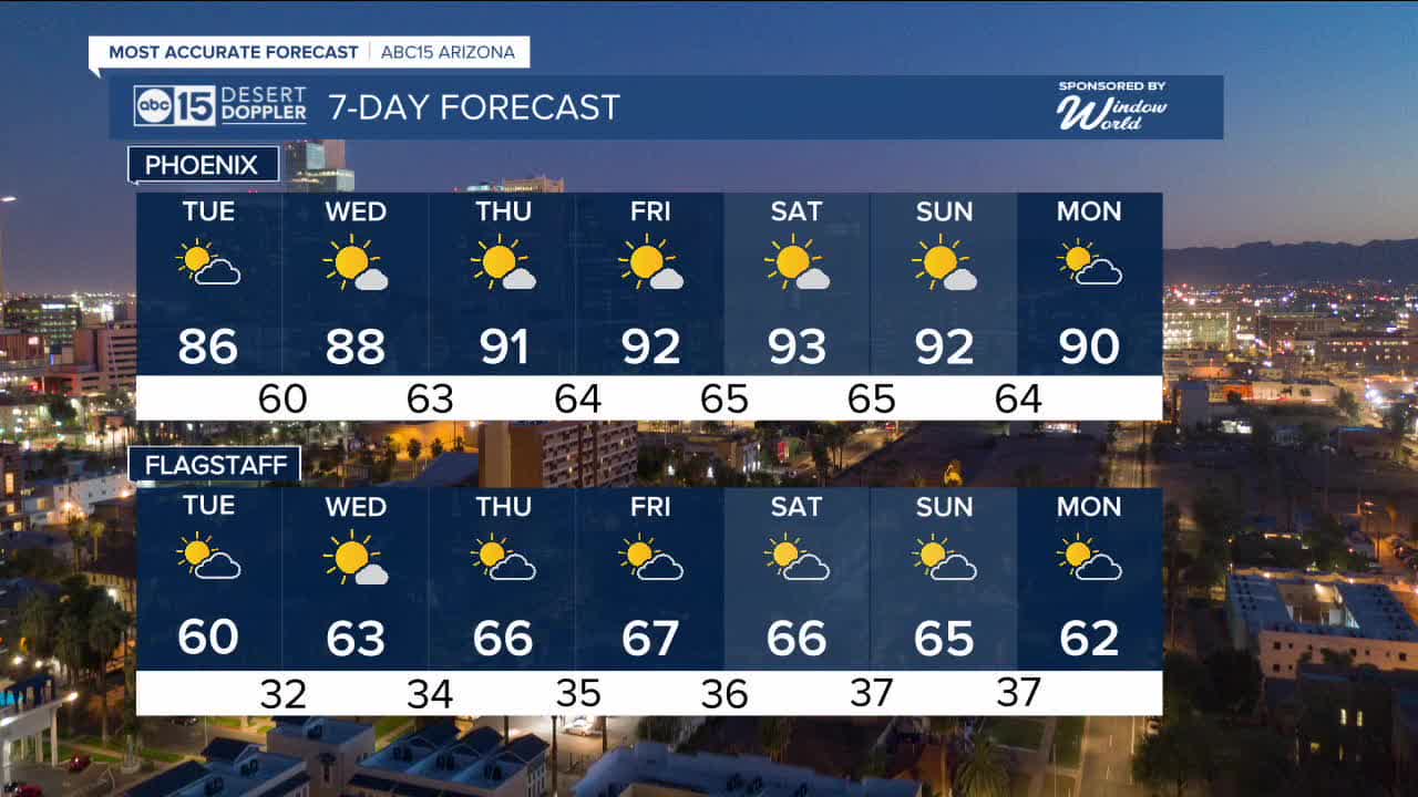
Temperatures across the Valley will climb into the mid 80s to upper 80s through the middle of the week, putting us around 15 degrees above normal.
By Thursday, Phoenix could hit the 90s for the first time this year.
On average, our first 90s don't come until late March, so this is around a month sooner than normal. We did hit the 90s last February though, marking our first 90-degree day on February 25th.
Phoenix has only had temperatures in the 90s in February 8 times on record, so temperatures this warm this soon have historically been very rare.
It's not just a one and done day in the 90s, either. Phoenix could hit the 90s 5 days in a row, starting Thursday and continuing through next Monday.
Daily records are also in jeopardy. Phoenix could tie or break each daily record high over that 5 day stretch in the 90s.
Overnight lows will get warmer, too. Starting Wednesday morning, lows in our warmest Valley spots are only expected to drop into the 60s.
Temperatures may drop slightly by the middle of next week as high pressure begins to weaken and a storm system potentially tracks through the Great Basin, but at this point the long-term outlook through the beginning of March has temperatures staying much warmer than normal.


2026 Sky Harbor Official Rainfall to date: 0.26" (-1.29" from average)
_________________________________________
2025 Sky Harbor Official Rainfall: 8.31" (+1.09" from average)
Monsoon 2025 Sky Harbor Official Rainfall: 2.76" (+0.33" from average)
__________________________________________
Daily rainfall reports from all across the Valley can be found here.
__________________________________________
PHOENIX IS GETTING DRIER - LOWER RAINFALL AVERAGES NOW
Average Monsoon Rainfall in Phoenix (1981-2010): 2.71" of rain
NEW Average Monsoon Rainfall in Phoenix (1991-2020): 2.43" of rain
Average Yearly Rainfall in Phoenix (1981-2010): 8:03" of rain
NEW Average Yearly Rainfall in Phoenix (1991-2020): 7.22" of rain
__________________________________________
Share your weather photos and videos with us anytime: share@abc15.com.
______________________________________
