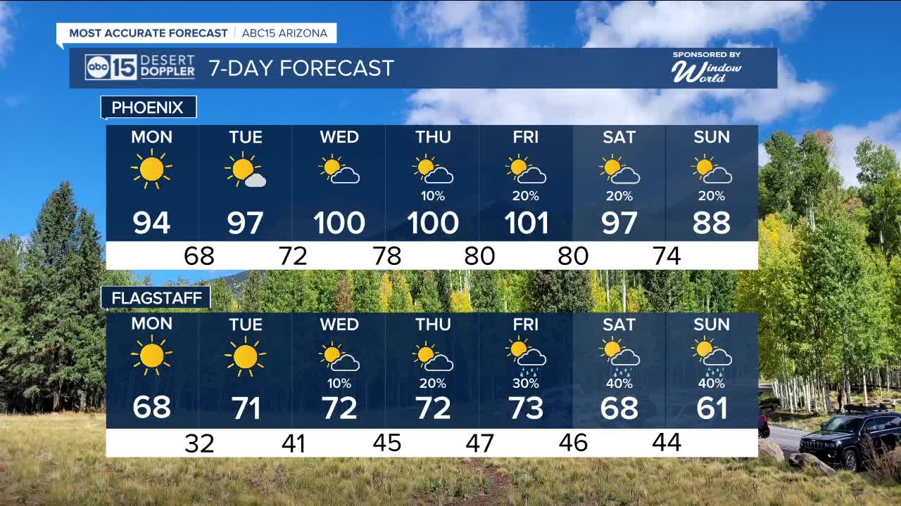


PHOENIX — After a beautiful fall weekend with below-average temperatures, get ready for a warm-up this week with the return of the triple digits.
The storm system to our north that brought our temperatures is lifting, and high pressure to our southeast will help bring temperatures up through the week.
With that being said, it is still going to be cool to start off Monday morning with valley lows in the 60s and even upper 50s. By the afternoon, we will warm up into the mid-90s.
By midweek, we will return to the triple digits, but a complex setup will occur for the late weekend and next weekend.
Remnant moisture from tropical system Priscilla is projected to be pushed to the northeast into the Desert Southwest. Additionally, a Pacific low will dip along the California coast and will help introduce instability. Where that energy goes will help determine the best area for showers.
Though the exact rainfall location and intensity are highly uncertain, there is a growing chance of rain for Arizona by late week and into the weekend.
Stay with ABC15 for the latest updates as we get closer.


_________________________________________
2025 Sky Harbor Official Rainfall to date: 4.23" (-1.21" from average)
Monsoon 2025 Sky Harbor Official Rainfall: 2.76" (+0.33" from average)
__________________________________________
Daily rainfall reports from all across the Valley can be found here.
__________________________________________
PHOENIX IS GETTING DRIER - LOWER RAINFALL AVERAGES NOW
Average Monsoon Rainfall in Phoenix (1981-2010): 2.71" of rain
NEW Average Monsoon Rainfall in Phoenix (1991-2020): 2.43" of rain
Average Yearly Rainfall in Phoenix (1981-2010): 8:03" of rain
NEW Average Yearly Rainfall in Phoenix (1991-2020): 7.22" of rain
__________________________________________
Share your weather photos and videos with us anytime: share@abc15.com.
______________________________________
