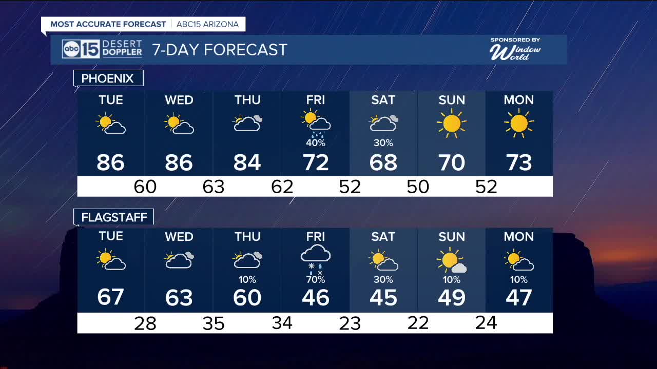


PHOENIX — It's going to be a gorgeous Veterans Day in the Valley!
Afternoon highs will reach the mid to upper 80s with overnight lows in the mid 50s to low 60s.
We'll see some passing clouds at times, but our forecast will stay dry through the middle of the week.
Then, get ready for some big changes by Friday as our next storm system moves in.
Winds will crank up, temperatures will drop and we'll even see chances for rain in the Valley on Friday and Saturday.
Up north, there's even a chance for snow in the high country!
On average, Flagstaff sees its first snowfall around November 11th, so this storm is right on cue.
Right now, the snow level looks to hover between 7,000 and 8,000 feet in elevation, so if we do see snow in Flagstaff it will be just a light dusting.
Here in the Valley, early model estimates indicate some neighborhoods could see more than a quarter of an inch of rain on Friday and Saturday as this storm system moves through.
The cooler air it will bring will drop temperatures dramatically as we head into the weekend.
Valley highs will fall into low 70s on Friday before plunging into the 60s by Saturday.
Early morning lows will dip into the upper 40s to low 50s over the weekend bringing our first fall chill to the Valley.
With these big changes ahead, make sure to stay tuned to ABC15 and abc15.com for updates on this storm as we get closer.


2025 Sky Harbor Official Rainfall to date: 7.49" (+1.40" from average)
Monsoon 2025 Sky Harbor Official Rainfall: 2.76" (+0.33" from average)
__________________________________________
Daily rainfall reports from all across the Valley can be found here.
__________________________________________
PHOENIX IS GETTING DRIER - LOWER RAINFALL AVERAGES NOW
Average Monsoon Rainfall in Phoenix (1981-2010): 2.71" of rain
NEW Average Monsoon Rainfall in Phoenix (1991-2020): 2.43" of rain
Average Yearly Rainfall in Phoenix (1981-2010): 8:03" of rain
NEW Average Yearly Rainfall in Phoenix (1991-2020): 7.22" of rain
__________________________________________
Share your weather photos and videos with us anytime: share@abc15.com.
______________________________________
