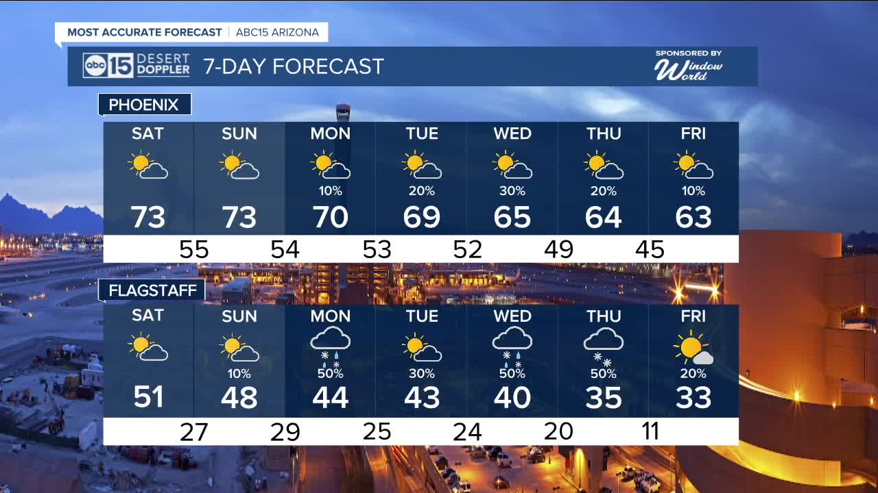


PHOENIX — Temperatures are back on the rise this weekend as our forecast dries out.
Valley highs will top out in the low to mid 70s with overnight lows in the upper 40s to mid 50s on Saturday and Sunday.
We are tracking a couple of storm systems next week that could bring cooler air, rain and snow back to Arizona.
Right now, our best chances for rain in the Valley look to be Tuesday night into Wednesday.
Up north, we could see a mix of rain and snow showers next week with the best chances for accumulating snowfall along the Mogollon Rim happening on Thursday.
We'll keep you posted as to how much rain and snow we could get as we get closer.
Temperatures will drop, too. In fact, highs in the Valley could fall into the low to mid 60s toward the end of next week. Average for this time of year is 66 degrees in Phoenix.
The long-term outlook for January has odds favoring warmer than normal conditions.
Phoenix just wrapped up its second-warmest year on record!
The average temperature for 2025 came in at 78.1 degrees, which is a half degree below the 2024 record of 78.6 degrees.


2026 Sky Harbor Official Rainfall to date: 0.03" (-0.03" from average)
__________________________________________
2025 Sky Harbor Official Rainfall: 8.31" (+1.09" from average)
Monsoon 2025 Sky Harbor Official Rainfall: 2.76" (+0.33" from average)
__________________________________________
Daily rainfall reports from all across the Valley can be found here.
__________________________________________
PHOENIX IS GETTING DRIER - LOWER RAINFALL AVERAGES NOW
Average Monsoon Rainfall in Phoenix (1981-2010): 2.71" of rain
NEW Average Monsoon Rainfall in Phoenix (1991-2020): 2.43" of rain
Average Yearly Rainfall in Phoenix (1981-2010): 8:03" of rain
NEW Average Yearly Rainfall in Phoenix (1991-2020): 7.22" of rain
__________________________________________
Share your weather photos and videos with us anytime: share@abc15.com.
______________________________________
