

PHOENIX — Monsoon moisture is flowing into Arizona and storm chances are back!
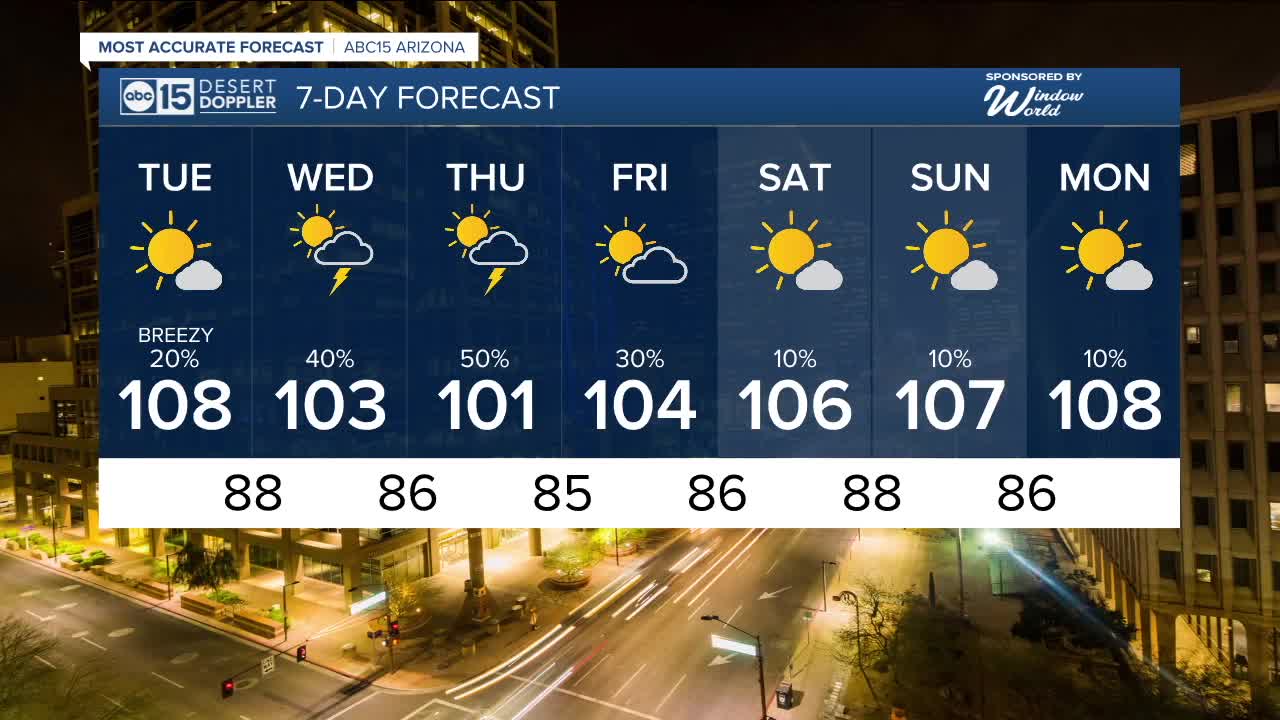
There's a slight chance of a few isolated storms in the Valley overnight and again Tuesday evening, but the best bet will be Wednesday night into Thursday.
That's when we could see all the typical monsoon threats, like gusty winds, blowing dust, frequent lightning strikes, heavy downpours and even flooding.
Temperatures will drop, too.
Much of the Valley will only top out in the upper 90s to low 100s Thursday afternoon.
We could see a few more storms on Friday before storm chances taper off over the weekend as drier air moves in.
Up north, more widespread monsoon activity will impact the high country throughout the week and over the weekend. Watch out for the possibility of flash flooding near any wildfire burn scars.
A Flood Watch is also in effect across parts of southern Arizona on Tuesday afternoon and evening. Do not attempt to drive through any flooded areas there. The road may be washed away underneath the flood waters. Stay safe and remember, "turn around, don't drown."
We are also tracking Extreme Heat Warnings which remain in effect for areas below 4,000 feet in the Grand Canyon through Wednesday.


2025 Sky Harbor Official Rainfall to date: 1.63" (-1.60" from average)
Monsoon 2025 Sky Harbor Official Rainfall: 0.16" (-0.15" from average)
_________________________________________
2024 Sky Harbor Official Rainfall to date: 4.54" (-2.68" from average)
Monsoon 2024 Sky Harbor Official Rainfall: 0.74" (-1.69" from average)
__________________________________________
Daily rainfall reports from all across the Valley can be found here.
__________________________________________
PHOENIX IS GETTING DRIER - LOWER RAINFALL AVERAGES NOW
Average Monsoon Rainfall in Phoenix (1981-2010): 2.71" of rain
NEW Average Monsoon Rainfall in Phoenix (1991-2020): 2.43" of rain
Average Yearly Rainfall in Phoenix (1981-2010): 8:03" of rain
NEW Average Yearly Rainfall in Phoenix (1991-2020): 7.22" of rain
__________________________________________
Share your weather photos and videos with us anytime: share@abc15.com.
______________________________________
