

PHOENIX — We are tracking an historic March heatwave for Arizona in the coming days.
As high pressure builds in, temperatures will soar to around 15 degrees above normal for this time of year.
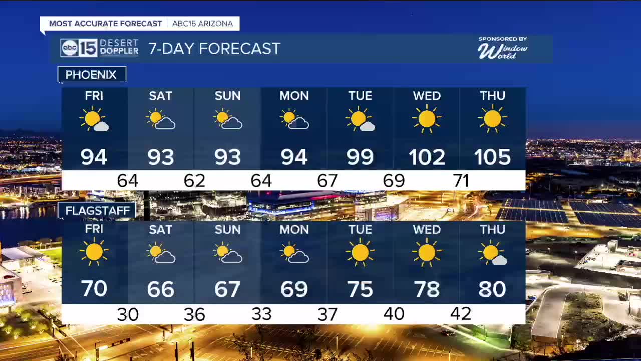
Here in the Valley, daytime highs will climb into the 90s over the next several days. Normal for mid-March is a high of 77 in Phoenix.
Daily heat records are in jeopardy too, especially on Friday and Sunday.
Then, the heat cranks up even more next week.
It's looking more likely that we could see our first triple digits of the year by next Tuesday or Wednesday, which could mark the earliest 100-degree day ever recorded in Phoenix.
Right now, the record-earliest triple-digit day is March 26, 1988. That is the only time Phoenix has ever hit 100 in the month of March so far, but next week it's looking like we could hit 100 or hotter multiple times.
As the heat builds in, make sure to limit your time outside and drink plenty of water.
By next Thursday, Phoenix could even climb to 105 degrees, which is nearly 30 degrees above normal! We typically don't see temperatures near 105 degrees until the end of May.
This triple-digit heatwave may continue through the following weekend, too.


2026 Sky Harbor Official Rainfall to date: 0.31" (-1.79" from average)
_________________________________________
Daily rainfall reports from all across the Valley can be found here.
__________________________________________
PHOENIX IS GETTING DRIER - LOWER RAINFALL AVERAGES NOW
Average Monsoon Rainfall in Phoenix (1981-2010): 2.71" of rain
NEW Average Monsoon Rainfall in Phoenix (1991-2020): 2.43" of rain
Average Yearly Rainfall in Phoenix (1981-2010): 8:03" of rain
NEW Average Yearly Rainfall in Phoenix (1991-2020): 7.22" of rain
__________________________________________
Share your weather photos and videos with us anytime: share@abc15.com.
______________________________________
