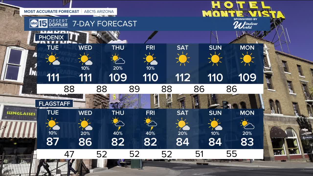


PHOENIX — High pressure is bringing the heat this week and sending temperatures soaring across Arizona!
Temperatures in the Valley are expected to hit 110 degrees or hotter for most of the week, increasing the risk of heat-related illnesses like heat exhaustion and heat stroke.
Make sure to limit your time outside between 10 a.m. and 6 p.m. and keep your pets inside, too.
If you must work outdoors, stay hydrated and take frequent breaks in the shade or inside to cool off.
Up north, an Extreme Heat Warning is in effect for parts of the Grand Canyon below 4,000 feet in elevation until 7 p.m. Wednesday. Temperatures down in the canyon could reach a dangerously hot 110 to 113 degrees.
Monsoon moisture is moving back in this week, bringing chances for showers and thunderstorms to eastern Arizona.
By Wednesday, we'll see a slight chance of a few isolated storms in the Valley and that chance will increase slightly on Thursday.
A few more isolated storms are possible in the Valley on Friday, but then we'll dry out and get a bit hotter over the weekend.


2025 Sky Harbor Official Rainfall to date: 1.63" (-2.11" from average)
Monsoon 2025 Sky Harbor Official Rainfall: 0.16" (-0.66" from average)
__________________________________________
Daily rainfall reports from all across the Valley can be found here.
__________________________________________
PHOENIX IS GETTING DRIER - LOWER RAINFALL AVERAGES NOW
Average Monsoon Rainfall in Phoenix (1981-2010): 2.71" of rain
NEW Average Monsoon Rainfall in Phoenix (1991-2020): 2.43" of rain
Average Yearly Rainfall in Phoenix (1981-2010): 8:03" of rain
NEW Average Yearly Rainfall in Phoenix (1991-2020): 7.22" of rain
__________________________________________
Share your weather photos and videos with us anytime: share@abc15.com.
______________________________________
