


PHOENIX — It's been an incredible year for weather records here in Phoenix.
A dangerous combination of climate change and urbanization is heating things up and fast!
Nearly every heat record imaginable was broken this year. Most of them not just broken by a little bit, but by a LONG shot.
Here's the breakdown:
- Most days at 95º or more: 172 this year. Old record was 166 in 1989.
- Most days at 100º or more: 145 this year. Old record was 143 days in 1989.
- Most days at 105º or more: 102 this year. Old record was 87 in 2002.
- Most days at 110º or more: 53 this year. Old record was 33 in 2011.
- Most days at 115º or more: 14 days this year. Old record was 7 days in 1974.
- Most days with lows at 90º or more: 28 days this year. Old record was 15 in 2013.
July was the hottest month ever recorded in Phoenix with an average temperature of 99.0º. (That's the high and low combined.) The previous record was 98.3º which we set in July of 2009 and August of 2011.
Then, we broke that record the very next month! August's average temperature hit 99.1º making it the hottest month ever recorded in Phoenix.
Overall, it was the hottest summer (June-August) on record with an average temperature of 96.7º. The old record was 95.1º set in 2013 and 2015.
Here's the breakdown for average highs/lows this summer:
AVERAGE HIGH: 108.5º
AVERAGE LOW: 84.9º
JUNE: AVERAGE HIGH 105.0º, AVERAGE LOW 79.1º
JULY: AVERAGE HIGH 109.8º, AVERAGE LOW 88.0º
AUGUST: AVERAGE HIGH 110.7º, AVERAGE LOW 87.4º
The other troubling statistic is the lack of rainfall.
In terms of the number of days with measurable rain here in Phoenix, it was the least active year on record for precipitation.
But in terms of total precipitation, it was the 28th driest on record for Phoenix.
The reason for this is linked to climate change, too.
Researchers at the University of Arizona have shown that climate change is leading to fewer rainy days here in Arizona (and longer periods of more extreme drought), but when the rain does come it's more intense. Since a warmer atmosphere can essentially hold more water vapor, we will see more "downpours" in a warmer world.
Here's a look at the trend across the country:
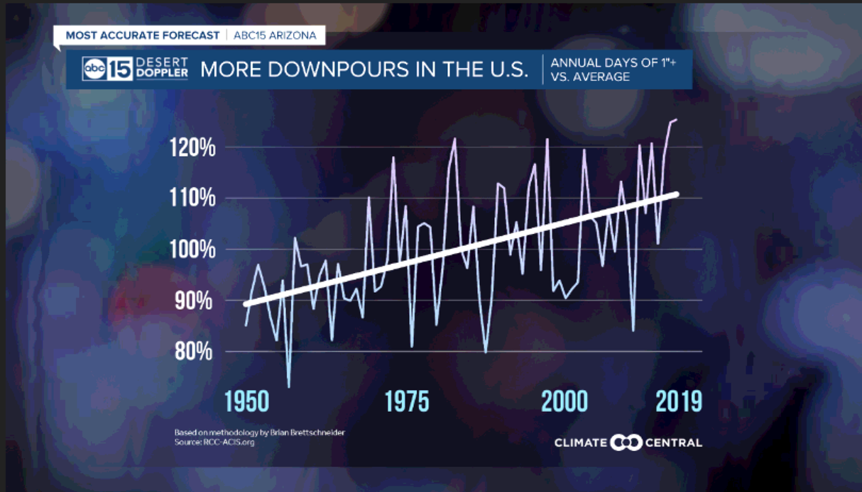
Here in Phoenix, a good example of this was August 20th this year. After an incredibly dry June and July, we had just the right ingredients in the atmosphere to lead to a night of incredibly intense storms. Sky Harbor picked up 0.90" inches of rain in less than 2 hours. That's nearly a month's worth of rain and 90% of our total monsoon rainfall this year.
La Nina set in this fall and winter, leading to more warm and dry conditions. We saw a few winter storms move through Arizona, but they didn't bring enough rain and snow to help our worsening drought.
With La Nina expected to be in effect through the spring, our long-term outlook shows a good chance of more warmer and drier-than-normal conditions in early 2021.
Here's the outlook for January, February and March from the NOAA Climate Prediction Center:
